Fobbing
| Fobbing | |
|---|---|
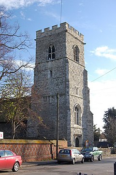
 Tower of St Michael's Church | |
Location within Essex | |
| OS grid reference | TQ715845 |
| Unitary authority | |
| Shire county | |
| Region | |
| Country | England |
| Sovereign state | United Kingdom |
| Post town | Stanford-le-Hope |
| Postcode district | SS17 9 |
| Police | Essex |
| Fire | Essex |
| Ambulance | East of England |
| UK Parliament | |
Fobbing is a small village in Thurrock, Essex, England and one of Thurrock's traditional (Church of England) parishes. It is located between Basildon and Corringham, and is also close to Stanford-le-Hope.
Fobbing is one of seven conservation areas in Thurrock.[1]
The now quiet village is renowned for its history, which includes being one of the main villages involved with the Peasants' Revolt. On 30 May 1381, the commissioner John Bampton summoned the Fobbing villagers, as well as villagers from Corringham and Stanford, to Brentwood to answer as to why they had not paid tax. The villagers told Bampton that they would give him nothing. Bampton then moved to arrest the villagers. A riot ensued in which the villagers attempted to kill Bampton. Bampton managed to escape to London. Sir Robert Belknap was sent to investigate the incident and to punish the offenders. On 2 June, he was attacked. By this time the violent discontent had spread, and the counties of Essex and Kent were in full revolt. Soon people moved on London in an armed uprising.[2][3] In 1981 a metal sculpture by B R Coode-Adams was erected as a memorial to the Peasants' Revolt at Fobbing to commemorate the 600th anniversary .
One of the major features of the village is St. Michael's Church. It is renowned for its historic association with the smuggling trade. Once upon a time the church was near the waterfront of Fobbing Harbour. Smugglers sailed up Fobbing Creek guided by the distinctive church tower but after the great flood of 1 February 1953, the creek and harbour were sealed up by a dyke and drained. Underneath the church are many tunnels which were used by the smugglers in the 14th century.
Public house

The White Lion public house is situated at the top of Lion Hill.
Notes
- ^ Thurrock Council | Natural & Historic Environment | Conservation Areas In Thurrock Archived 10 February 2009 at the Wayback Machine
- ^ Maurice Hugh Keen, England in the Later Middle Ages: a political history (Routledge, 1975)
- ^ Dedman, M., 2012. Peasants were revolting - and they did it right here. Brentwood Gazette, 6 Jun. p. 20.

