
BR-153 (Brazil highway): Difference between revisions
HerculeBot (talk | contribs) m r2.7.1) (Robot: Modifying pt:BR-153 |
ReneeWrites (talk | contribs) |
||
| (44 intermediate revisions by 26 users not shown) | |||
| Line 1: | Line 1: | ||
{{more citations needed|date=August 2014}} |
|||
'''Rodovia Transbrasiliana''' (''Transbrazilian Highway'') is a federal highway in [[Brazil]] (officially designated BR-153). |
|||
{{Expand Portuguese|topic=transp}} |
|||
{{Infobox road |
|||
|country=BRA |
|||
|alternate_name=Transbrasiliana Highway |
|||
|type=BR |
|||
|route=153 |
|||
|map=Br-153mapa.jpg |
|||
|length_mi=2234.14 |
|||
|length_round=2 |
|||
|length_ref= <ref>{{cite web|url=http://www2.transportes.gov.br/bit/02-rodo/3-loc-rodo/loc-rodo/br-153/gbr-153.htm|title=BR-153 length between major junctions.|publisher=Ministério dos Transportes do Brasil|access-date=August 15, 2014|archive-url=https://web.archive.org/web/20131109081719/http://www2.transportes.gov.br/bit/02-rodo/3-loc-rodo/loc-rodo/br-153/gbr-153.htm|archive-date=2013-11-09|url-status=dead}}</ref> |
|||
|established=February 1, 1959 |
|||
|direction_a=North |
|||
|terminus_a= [[São Domingos do Araguaia]], [[Pará]] |
|||
|junction=[[TO-222]] in [[Araguaína]], [[Tocantins|TO]]<br/>[[TO-080]] in [[Paraíso do Tocantins]], [[Tocantins|TO]]<br/>[[BR-060]] in [[Goiânia]], [[Goiás|GO]]<br/>[[BR-456]] in [[São José do Rio Preto]], [[São Paulo (state)|SP]]<br/>[[BR-277]] in [[Irati, Paraná|Irati]], [[Paraná (state)|PR]]<br/>[[File:BR-285.png|18px]] [[BR-285]] in [[Passo Fundo]], [[Rio Grande do Sul|RS]]<br/>[[File:BR-386.png|18px]] [[BR-386]] in [[Soledade]], [[Rio Grande do Sul|RS]]<br/>[[File:Rs-403 shield.svg|20px]] [[RS-403]] in [[Cachoeira do Sul]], [[Rio Grande do Sul|RS]] |
|||
|direction_b=South |
|||
|terminus_b= [[Aceguá, Brazil|Aceguá]], [[Rio Grande do Sul]] / Brazil-Uruguay border |
|||
}} |
|||
'''BR-153''' is a major [[Brazilian Highway System|federal highway]] of [[Brazil]], officially named the '''Transbrasiliana Highway'''. It also serves as part of the '''[[Belém–Brasília Highway]]''' in the stretch located between the cities of [[Wanderlândia]], in the state of [[Tocantins]], and [[Anápolis]], in the state of [[Goiás]].<ref>[https://www.gov.br/dnit/pt-br/download/rodovias/rodovias-federais/nomeclatura-das-rodovias-federais/rodovias-longitudinais.pdf Rodovias Longitudinais]</ref> |
|||
| ⚫ | It crosses Brazil in |
||
| ⚫ | It crosses Brazil in a north–south direction, starting in [[São Domingos do Araguaia]], in the state of [[Pará]] and ending in [[Aceguá, Brazil|Aceguá]], in the state of [[Rio Grande do Sul]] on the Brazil/Uruguay border. The highway, highly variable in quality and traffic, cuts through the states of [[Pará]], [[Tocantins]], [[Goiás]], [[Minas Gerais]], [[São Paulo (state)|São Paulo]], [[Paraná (state)|Paraná]], [[Santa Catarina (state)|Santa Catarina]] and [[Rio Grande do Sul]]. |
||
== Duplication == |
|||
A 315 km section between [[Anápolis]] and [[Monte Alegre de Minas]] has already been duplicated. |
|||
In 2020, the Federal Government plans to grant 850.7 km of the highway to the private sector, in the Anápolis (GO) section to Aliança (TO), to double 623.4 km of the section.<ref>[https://www.correiobraziliense.com.br/app/noticia/economia/2020/04/14/internas_economia,844546/projeto-de-concessao-da-br-153-em-goias-e-enviado-para-o-tcu.shtml Projeto de concessão da BR-153, em Goiás, é enviado para o TCU ]</ref> |
|||
==Gallery== |
|||
<gallery> |
|||
BR-153 no Tocantins.jpg|Stretch of BR-153 in [[Fortaleza do Tabocão]], [[Tocantins]]. |
|||
Divisa GO-TO na BR-153.JPG|BR-153 on the Tocantins/[[Goiás]] state line. |
|||
BR-153 em Araguaína.jpg|Urban segment of BR-153 in [[Araguaína]], Tocantins. |
|||
BR-153 em Goiás.JPG|Section of BR-153 in [[Campinorte]], [[Goiás]]. |
|||
BR-060 em Goiânia.JPG|Stretch concurrent with [[BR-060]] in [[Goiânia]]. |
|||
BR-153 em Goiânia.jpg|Urban segment of BR-153 in Goiânia. |
|||
BR-153 PAVOTEC.jpg|BR-153 in [[Minas Gerais]] |
|||
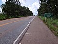
BR-153 no Paraná.jpg|Precarious stretch of BR-153 in the rural area of [[Mallet, Paraná|Mallet]], [[Paraná (state)|Paraná]], 2013 |
|||
Moto Clube FREE WORLD na estrada.jpg|BR-153 in [[Herveiras]], [[Rio Grande do Sul]] |
|||
BR-153 no Rio Grande do Sul.jpg|Segment of BR-153 in rural [[Cachoeira do Sul]], [[Rio Grande do Sul]]. |
|||
</gallery> |
|||
==See also== |
==See also== |
||
*Paleorrota Geopark |
|||
* [[Belém–Brasília Highway]] |
|||
* [[Brazilian Highway System]] |
* [[Brazilian Highway System]] |
||
* [[Route 8 (Uruguay)|Route 8]] ([[Uruguay]]) |
|||
* [[Rodovia Belém-Brasília]] |
|||
==References== |
|||
{{Reflist}} |
|||
==External links== |
==External links== |
||
* [http:// |
* [https://web.archive.org/web/20131109081719/http://www2.transportes.gov.br/bit/02-rodo/3-loc-rodo/loc-rodo/br-153/gbr-153.htm BR-153 Highway]. [[Ministry of Transport (Brazil)|Ministry of Transport]] of [[Brazil]]. |
||
{{Federal roads of Brazil}} |
{{Federal roads of Brazil}} |
||
| ⚫ | |||
| ⚫ | |||
[[fr:BR-153]] |
|||
[[pt:BR-153]] |
|||
Latest revision as of 14:26, 3 April 2024
This article needs additional citations for verification. (August 2014) |
You can help expand this article with text translated from the corresponding article in Portuguese. Click [show] for important translation instructions.
|
 | |
|---|---|
| Transbrasiliana Highway | |
 | |
| Route information | |
| Length | 2,234.14 mi[1] (3,595.50 km) |
| Existed | February 1, 1959–present |
| Major junctions | |
| North end | São Domingos do Araguaia, Pará |
| TO-222 in Araguaína, TO TO-080 in Paraíso do Tocantins, TO BR-060 in Goiânia, GO BR-456 in São José do Rio Preto, SP BR-277 in Irati, PR | |
| South end | Aceguá, Rio Grande do Sul / Brazil-Uruguay border |
| Location | |
| Country | Brazil |
| Highway system | |
BR-153 is a major federal highway of Brazil, officially named the Transbrasiliana Highway. It also serves as part of the Belém–Brasília Highway in the stretch located between the cities of Wanderlândia, in the state of Tocantins, and Anápolis, in the state of Goiás.[2]
It crosses Brazil in a north–south direction, starting in São Domingos do Araguaia, in the state of Pará and ending in Aceguá, in the state of Rio Grande do Sul on the Brazil/Uruguay border. The highway, highly variable in quality and traffic, cuts through the states of Pará, Tocantins, Goiás, Minas Gerais, São Paulo, Paraná, Santa Catarina and Rio Grande do Sul.
Duplication[edit]
A 315 km section between Anápolis and Monte Alegre de Minas has already been duplicated.
In 2020, the Federal Government plans to grant 850.7 km of the highway to the private sector, in the Anápolis (GO) section to Aliança (TO), to double 623.4 km of the section.[3]
Gallery[edit]
-
 Stretch of BR-153 in Fortaleza do Tabocão, Tocantins.
 -
 BR-153 on the Tocantins/Goiás state line.
 -
 Urban segment of BR-153 in Araguaína, Tocantins.
 -
 Section of BR-153 in Campinorte, Goiás.
 -

-
 Urban segment of BR-153 in Goiânia.
 -
 BR-153 in Minas Gerais
 -

-
 BR-153 in Herveiras, Rio Grande do Sul
 -
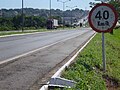
 Segment of BR-153 in rural Cachoeira do Sul, Rio Grande do Sul.


See also[edit]
- Paleorrota Geopark
- Belém–Brasília Highway
- Brazilian Highway System
- Route 8 (Uruguay)
References[edit]
- ^ "BR-153 length between major junctions". Ministério dos Transportes do Brasil. Archived from the original on 2013-11-09. Retrieved August 15, 2014.
- ^ Rodovias Longitudinais
- ^ Projeto de concessão da BR-153, em Goiás, é enviado para o TCU
External links[edit]
| Radial highways (originating from Brasília) | |
|---|---|
| North-south highways | |
| East-west highways | |
| Diagonal highways | |
| Link highways |
|