
Cachoeira do Sul
| Município de Cachoeira do Sul
"Capital Nacional do Arroz"
Cachoeira do Sul
"Princesa do Jacuí" |
|||
|---|---|---|---|
 |
|||
|
|||
| Coordinates | 30 ° 2 ′ S , 52 ° 54 ′ W | ||
 Location of the municipality in the state of Rio Grande do Sul Location of the municipality in the state of Rio Grande do Sul
|
|||
| Symbols | |||
|
|||
| founding | 26th April 1819 (age 201) | ||
| Basic data | |||
| Country | Brazil | ||
| State | Rio Grande do Sul | ||
| ISO 3166-2 | BR-RS | ||
| structure | 7 districts | ||
| height | 26 m | ||
| Waters | Rio Jacuí | ||
| climate | tropical, Cfa | ||
| surface | 3735 km² | ||
| Residents | 83,827 (2010) | ||
| density | 22.4 Ew. / km² | ||
| estimate | 82,201 (July 1, 2019) | ||
| Parish code | IBGE : 4303004 | ||
| Post Code | 96505-000 to 96529-999 | ||
| Telephone code | (+55) 51 | ||
| Time zone | UTC −3 | ||
| politics | |||
| City Prefect | Sergio Ghignatti (2017-2020) | ||
| Political party | PDT | ||
| economy | |||
| GDP | 2,323,460 thousand R $ 27,143 R $ per capita (2016) |
||
| HDI | 0.742 (2010) | ||
 Schematic distribution of named neighborhoods ( bairros )
|
|||


Cachoeira do Sul , German waterfall of the south , officially Portuguese Município de Cachoeira do Sul , is a city and municipality in the Brazilian state of Rio Grande do Sul in the Sul region . The population was estimated as of July 1, 2019 at 82,201 inhabitants, who live in a community area of around 3735 km² and are called Cachoeirensians.
The distance to the capital Porto Alegre is 196 km. It is nicknamed the National Rice Capital . In addition to rice cultivation and processing as well as wheat cultivation, the community is also known for the production of pecans and cattle farming.
Together with six other municipalities, it forms the state development region COREDE Jacuí-Centro .
geography
The main town of the municipality is located on the left bank of the Rio Jacuí , which is navigable by boat from the Rio Guaíba upstream to Cachoeira do Sul.
Surrounding communities are in the north Novo Cabrais , Candelária , Paraíso do Sul , in the east Rio Pardo , in the south Encruzilhada do Sul , Santana da Boa Vista , Caçapava do Sul , in the west São Sepé and Restinga Sêca .
The biome is pampas with hilly grassland, formerly also Mata Atlântica . The community is located in the large central depression of Rio Grande do Sul. The community has numerous streams, rivers and lakes, in particular the smaller streams irrigate the rice fields.
climate
The community has a tropical temperate climate, Cfa according to the Köppen and Geiger climate classification . The average temperature is 19.4 ° C. The average rainfall is 1416 mm per year.
| Jan | Feb | Mar | Apr | May | Jun | Jul | Aug | Sep | Oct | Nov | Dec | |||
| Temperature ( ° C ) | 24.8 | 23.7 | 20.9 | 18.2 | 15.4 | 14.8 | 15.2 | 16.4 | 18.4 | 20.7 | 23.2 | 21.0 | O | 19.4 |
| Precipitation ( mm ) | 140 | 135 | 141 | 106 | 99 | 107 | 106 | 105 | 118 | 116 | 121 | 122 | Σ | 1416 |
history
In the 16th and 17th centuries it was the passage area of Bandeirantes , and Azorean settlers were brought to the wide prairies in the west during the colonial wars to support the military . The indigenous Guaraní population living there was converted to Christianity by Spanish Jesuits. After the Guaraní War , catechetical Indians had a village on the Rio Jacuí near the “Passo do Fandango” known as the rapids, where a chapel, the Capela de São Nicolau , had been built , today in the Aldeia district . On July 10, 1779 the parish Freguesia de São Nicolau da Cachoeira de San José was established, renamed in 1781 in Freguesia de Nossa Senhora da Conceição de Cachoeira . The parish was subordinate to the Bishop of Rio de Janeiro, administratively the parish was subordinate to the Vila do Rio Pardo (today Rio Pardo ). Land and the sesmarias were distributed to the military . Black African slaves were acquired for field work.
From 1807 to 1821 the country belonged to the São Pedro do Rio Grande do Sul captaincy , then to the São Pedro do Rio Grande do Sul province , both forerunners of today's federal state.
By a royal decree ( alvará ) of July 26, 1819, it was raised by King João VI to Vila Nova de São João da Cachoeira , the actual emancipation did not take place until October 5, 1820, which is considered the date of foundation and is listed in the city arms. It formed the last of five very large administrative districts in the early Rio Grande do Sul of the transition from the Kingdom of Portugal to the Empire of Brazil . The community went through the complete sequence of a Brazilian city development: first village, then Vila (1819), then Cidade (December 15, 1859) with renaming in Cachoeira. In 1944 the community was renamed Cachoeira do Sul due to the same name as other Brazilian towns . It played a role in the independence movements and riots in the 19th century, particularly in the Farrapen Revolution and the short-lived Piratini Republic . An urban elite had formed mainly from large landowners. Urban planning was carried out with seriousness but not always with success, so square blocks of flats were built following the Portuguese model with strict requirements for house construction, but there were more and more building applications from property owners in the first half of the 19th century. The main town of the municipality did not get beyond the status of a small town until the 20th century, the municipal area was given in 1900 with 6002 km², on which a total of only 32,510 inhabitants lived.
German agricultural colonies
The arrival in 1857 of German settlers, most of whom came from Pomerania, was significant for Cachoeira. The primary colony was the former Colônia Santo Ângelo , which was in what is now Agudo , Paraíso do Sul and Cachoeira. They introduced rice cultivation in the region. Italian immigrants followed around 1880. For tax collection reasons, it was decided at the end of the 19th century to divide the municipality into six large districts, whereby the colonization area was broken up and the colony could not develop into an independent city.
Local government
The executive rests with the city prefect (mayor). In the local elections in 2016 , Sergio Ghignatti of the Partido Democrático Trabalhista (PDT) was elected city prefect for the term from 2017 to 2020.
The legislature lies with a 15-member elected city council, the vereadores of the Câmara de Vereadores.
Since 1960, the community has been divided into seven administrative districts: Distrito de Cachoeira do Sul (municipal seat ), Distrito de Barro Vermelho , Distrito de Capané , Distrito de Cordilheira , Distrito de Bosque , Distrito de Ferreira and the Distrito de Três Vendas .
Population development
In 1872, 11,756 people lived in Cachoeira, of which 9,620 were free citizens and 2,136 were slaves. An increasing rural exodus can be observed from the 1980s.
| year | Residents | city | country |
|---|---|---|---|
| 1900 | 32,510 | ||
| 1920 | 58,578 | ||
| 1940 | 83,729 | 19,621 | 64,108 |
| 1950 | 94.110 | 26,374 | 67,736 |
| 1960 * | 84,512 | 40.234 | 44,278 |
| 1970 | 94,261 | 52,044 | 42,217 |
| 1980 | 93,341 | 62.105 | 31,236 |
| 1991 ** | 85,456 | 71,222 | 14,234 |
| 2000 | 87,873 | 74.119 | 13,754 |
| 2010 | 83,827 | 71,700 | 12,127 |
| 2019 | 82.201 | ? | ? |
 |
|||
Source: IBGE (2011)
- Note *: Territorial reforms, loss of mainly rural parts
- Note **: Deviation for 1991 within two IBGE figures: 3692 people
Ethnic composition
Ethnic groups according to the statistical classification of the IBGE (as of 2000 with 87,873, as of 2010 with 83,827 inhabitants):
| group | Share 2000 |
Share 2010 |
annotation |
|---|---|---|---|
| Brancos | 76,376 | 70,570 | Whites, descendants of Europeans |
| Pretus | 6,306 | 6,636 | black |
| Pardos | 4,879 | 6,429 | Mixed races, mulattos , mestizos |
| Amarelos | 0 | 167 | Asians |
| Indigenous people | 128 | 25 | indigenous population |
| without specification | 184 | - |
Average income and standard of living
In 2017, the average monthly income was 2.2 times the Brazilian minimum wage ( Salário mínimo ) of R $ 880.00 (income converted for 2019: around € 438 per month). The Human Development Index (HDI) is rated high at 0.742 for 2010.
In 2017, 16,327 people or 19.1% of the population were registered as permanently employed; 31.2% of the population had an income of half the minimum wage in 2010.
| HDI | ||||
|---|---|---|---|---|
| year | Points | |||
| 1991 | 0.546 | |||
| 2000 | 0.661 | |||
| 2010 | 0.742 | |||
The gross national product per capita in 2016 was R $ 27,143.23, the gross national product of the municipality was R $ 2,323,460.38 × thousand in 2016.
education
Illiteracy rate
Cachoeira do Sul had an illiteracy rate of 18% in 1991 (including incomplete primary education), which had already fallen to 9% in the 2010 census. Around 20.1% of the population in 2010 were children and adolescents up to the age of 15.
| Illiteracy rate | ||||
|---|---|---|---|---|
| year | percent | |||
| 1991 | 17.96 | |||
| 2000 | 12.80 | |||
| 2010 | 9.02 | |||
Higher education
Both the denominational Universidade Luterana do Brasil (ULBRA) and the state-owned Universidade Estadual do Rio Grande do Sul (UERGS) maintain a campus in Cachoeira do Sul.
Culture
Buildings
Cultural and architectural monuments are subordinate to the Conselho Municipal do Patrimônio Histórico-Cultural (COMPAHC, Municipal Council for Historical-Cultural Heritage ), founded in 1981 .
The Museu Municipal de Cachoeira do Sul is a regional museum, the building has had various functions since its construction in 1865, stylistically it combines elements from the colonial style of the colonial era of Brazil and neoclassicism . The building is a historical monument.
The “Cine-Teatro Coliseu” , which opened in 1938 and was built in Art Deco style , also received monument status.
selection
The main church Catedral Nossa Senhora da Conceição was built from 1793 and consecrated on September 30, 1799. It is built in the Portuguese-Brazilian colonial style, has undergone some renovations and has been a listed building since 1985.
The "Palácio Legislativo João Neves da Fontoura" has been a monument since 1985. It was built for the company Azevedo Moura & Gertrum in 1927 in neoclassical style, housed the provincial bank and has been the seat of the city council since 1983.

Martin Luther Temple, built by Theodor Wiederspahn

Cathedral of Nossa Senhora da Conceição

Palácio Legislativo

Seat of the city museum


media
The leading news organ is the newspaper Jornal do Povo , which has been published since 1929 .
traffic
The BR-153 runs through the city in a north-south direction, while the state road RS-403 ends here when coming from the east . The east-west BR-290 motorway meets the BR-153 further south. In the village, the BR-153 crosses the Ponte de Fandango bridge, inaugurated in 1961, at the Barragem do Fandango lock weir . The river port of Porto de Cachoeira do Sul is still not completed.

Bridge over the Rio Jacuí
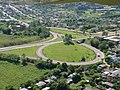
Panoramic view with feeder roundabout, BR-153


To the northwest of the town center is the Cachoeira do Sul airport ( Aeroporto de Cachoeira do Sul Nero Moura ). In the north of the city center was the former station of the Estrada de Ferro Porto Alegre-Uruguaiana , it was inaugurated in 1883 and ensured the upswing of the then small town. In 1973 the station was shut down because the Cachoeira do Sul-Nova station was built for a new route in 1973 , in the Oliveira district further away from the city center. The old station building was torn down to redesign the square and the rails were removed.
Sports
The place has the football clubs Cachoeira Futebol Clube and Grêmio Esportivo São José .
Diocese of Cachoeira do Sul
The place is the seat of the diocese of Cachoeira do Sul .
sons and daughters of the town
- João Neves da Fontoura (1887–1963), politician and author
- Francisco Mauro Salzano (1928-2018), geneticist
- Alcione Sortica , called "Caco" (* 1935), writer
- Gottfried Brakemeier (* 1937), German-Brazilian theologian and university professor
- Marlon Santos (born 1995), football player
literature
- Anuário Cachoeira do Sul .
- Inventário Turístico da Cidade. Cachoeira do Sul 2018 (PDF; 27.28 MB; Brazilian Portuguese, describes the sights).
Web links
- City Prefecture website , Prefeitura Municipal (Brazilian Portuguese)
- City Council website , Câmara de Vereadores (Brazilian Portuguese)
- Website of the Conselho Municipal do Patrimônio Histórico-Cultural
Individual evidence
- ↑ a b c Cachoeira do Sul - Panorama. In: cidades.ibge.gov.br. IBGE , accessed November 22, 2019 (Brazilian Portuguese).
- ↑ Corede Jacuí Centro. In: www.fee.rs.gov.br. FEE - Fundação de Economia e Estatística, accessed November 22, 2019 (Brazilian Portuguese).
- ^ Jacuí River. In: britannica.com. Encyclopedia Britannica , accessed November 22, 2019 .
- ↑ Cachoeira do Sul climate: average temperature, weather by month, Cachoeira do Sul weather averages - Climate-Data.org. In: de.climate-data.org. Retrieved November 22, 2019 .
- ↑ Cachoeiro do Sul - História. In: cidades.ibge.gov.br. IBGE , accessed November 22, 2019 (Brazilian Portuguese).
- ↑ A Cidade. In: www.cachoeiradosul.rs.gov.br. Prefeirua Municipal de Cachoeira do Sul, accessed November 23, 2019 (Brazilian Portuguese).
- ↑ William Werlang: História da Colônia Santo Ângelo. Volume 1. Editora Pallotti, 1995.
- ↑ Sérgio Ghignatti 12 (Prefeito). In: todapolitica.com. Eleições 2016, accessed November 22, 2019 (Brazilian Portuguese).
- ^ A b Atlas do Desenvolvimento Humao no Brasil: Cachoeira do Sul, RS . Retrieved November 22, 2019 (Brazilian Portuguese)
- ↑ Censos demográficos do IBGE (1872-2010). Evolução da divisão territorial do Brasil 1872–2010 , p. 242. (Online; PDF; 125.3 MB)
- ↑ IBGE : Sistema IBGE de Recuperação Automática - SIDRA: Tabela 2093. Retrieved on November 22, 2019 (Portuguese, database query, search terms Cachoeiro do Sul (RS) and Cor ou raça).
- ↑ Cachoeira do Sul - Panorama - Trabalho e rendimento. In: cidades.ibge.gov.br. IBGE , accessed November 22, 2019 (Brazilian Portuguese).
- ↑ Cachoeira do Sul - Produto Interno Bruto dos Municipios. In: cidades.ibge.gov.br. IBGE , accessed November 22, 2019 (Brazilian Portuguese).
- ↑ ULBRA Cachoeira do Sul. In: www.ulbra.br. Universidade Luterana do Brasil, accessed November 22, 2019 .
- ^ Cachoeira do Sul. In: www.uergs.edu.br. UERGS - Universidade Estadual do Rio Grande do Sul, 2016, accessed on November 22, 2019 .
- ^ Museu Municipal de Cachoeira do Sul. In: www.museucachoeira.com.br. www.museucachoeira.com.br, accessed November 23, 2019 .
- ↑ Jornal do Povo website .
- ↑ Mirian Ritzel: Barragem-Ponte do Fandango: cinquenta anos. In: www.museucachoeira.com.br. Museu Municipal de Cachoeira do Sul, January 25, 2011, accessed November 22, 2019 (Brazilian Portuguese).
- ↑ A Ponte do Fandango, as pontes secas e os aterros. In: arquivohistoricodecachoeiradosul.blogspot.com. Arquivo Histórico de Cachoeira do Sul, January 8, 2016, accessed November 22, 2019 (Brazilian Portuguese).
- ↑ Ralph Mennucci Giesbrecht: Cachoeira do Sul on the website Estações Ferroviárias do Brasil . Retrieved November 22, 2019 (Brazilian Portuguese).
- ↑ Ralph Mennucci Giesbrecht: Cachoeira do Sul-Nova on the website Estações Ferroviárias do Brasil . Retrieved November 22, 2019 (Brazilian Portuguese).
- ↑ Alcione Sortica website. Retrieved November 23, 2019 .