
BR-153 (Brazil highway): Difference between revisions
Content deleted Content added
Chaswmsday (talk | contribs) →Gallery: Copyedited, removed duplicate links, repaired redlink. |
m Bot: galleries syntax and minor changes |
||
| Line 15: | Line 15: | ||
|junction=[[TO-222]] in [[Araguaína]], [[Tocantins|TO]]<br/>[[TO-080]] in [[Paraíso do Tocantins]], [[Tocantins|TO]]<br/>[[BR-060]] in [[Goiânia]], [[Goiás|GO]]<br/>[[BR-456]] in [[São José do Rio Preto]], [[São Paulo (state)|SP]]<br/>[[BR-277]] in [[Irati, Paraná|Irati]], [[Paraná (state)|PR]]<br/>[[File:BR-285.png|18px]] [[BR-285]] in [[Passo Fundo]], [[Rio Grande do Sul|RS]]<br/>[[File:BR-386.png|18px]] [[BR-386]] in [[Soledade]], [[Rio Grande do Sul|RS]]<br/>[[File:Rs-403 shield.png|20px]] [[RS-403]] in [[Cachoeira do Sul]], [[Rio Grande do Sul|RS]] |
|junction=[[TO-222]] in [[Araguaína]], [[Tocantins|TO]]<br/>[[TO-080]] in [[Paraíso do Tocantins]], [[Tocantins|TO]]<br/>[[BR-060]] in [[Goiânia]], [[Goiás|GO]]<br/>[[BR-456]] in [[São José do Rio Preto]], [[São Paulo (state)|SP]]<br/>[[BR-277]] in [[Irati, Paraná|Irati]], [[Paraná (state)|PR]]<br/>[[File:BR-285.png|18px]] [[BR-285]] in [[Passo Fundo]], [[Rio Grande do Sul|RS]]<br/>[[File:BR-386.png|18px]] [[BR-386]] in [[Soledade]], [[Rio Grande do Sul|RS]]<br/>[[File:Rs-403 shield.png|20px]] [[RS-403]] in [[Cachoeira do Sul]], [[Rio Grande do Sul|RS]] |
||
|direction_b=South |
|direction_b=South |
||
|terminus_b= |
|terminus_b= [[Aceguá, Brazil|Aceguá]], [[Rio Grande do Sul]] / Brazil-Uruguay border |
||
}} |
}} |
||
| Line 29: | Line 29: | ||
BR-060 em Goiânia.JPG|Stretch concurrent with [[BR-060]] in [[Goiânia]]. |
BR-060 em Goiânia.JPG|Stretch concurrent with [[BR-060]] in [[Goiânia]]. |
||
BR-153 em Goiânia.jpg|Urban segment of BR-153 in Goiânia. |
BR-153 em Goiânia.jpg|Urban segment of BR-153 in Goiânia. |
||
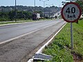
Br_153.jpg |
Br_153.jpg|Hazardous stretch of BR-153 between [[Imbituva]], [[Paraná (state)|Paraná]] and [[Irati, Paraná]]. |
||
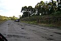
BR-153 no Rio Grande do Sul.jpg|Segment of BR-153 in rural [[Cachoeira do Sul]], [[Rio Grande do Sul]]. |
BR-153 no Rio Grande do Sul.jpg|Segment of BR-153 in rural [[Cachoeira do Sul]], [[Rio Grande do Sul]]. |
||
</gallery> |
</gallery> |
||
Revision as of 05:38, 19 August 2017
This article needs additional citations for verification. (August 2014) |
| BR-153 | |
|---|---|
| Transbrasiliana Highway | |
 | |
| Route information | |
| Length | 2,234.14 mi[1] (3,595.50 km) |
| Existed | February 1, 1959–present |
| Major junctions | |
| North end | São Domingos do Araguaia, Pará |
| TO-222 in Araguaína, TO TO-080 in Paraíso do Tocantins, TO BR-060 in Goiânia, GO BR-456 in São José do Rio Preto, SP BR-277 in Irati, PR | |
| South end | Aceguá, Rio Grande do Sul / Brazil-Uruguay border |
| Location | |
| Country | Brazil |
| Highway system | |
BR-153 is a major federal highway of Brazil, officially named the Transbrasiliana Highway. It also serves as part of the Belém-Brasília Highway in the stretch located between the cities of Wanderlândia, in the state of Tocantins, and Anápolis, in the state of Goiás.
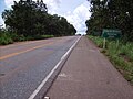
It crosses Brazil in a north-south direction, starting in São Domingos do Araguaia, in the state of Pará and ending in Aceguá, in the state of Rio Grande do Sul on the Brazil/Uruguay border. The highway, highly variable in quality and traffic, cuts through the states of Pará, Tocantins, Goiás, Minas Gerais, São Paulo, Paraná, Santa Catarina and Rio Grande do Sul.
Gallery
-
 Stretch of BR-153 in Fortaleza do Tabocão, Tocantins.
 -
 BR-153 on the Tocantins/Goiás state line.
 -
 Urban segment of BR-153 in Araguaína, Tocantins.
 -

-
 Urban segment of BR-153 in Goiânia.
 -
-
 Segment of BR-153 in rural Cachoeira do Sul, Rio Grande do Sul.


See also
- Paleorrota Geopark
- Belém-Brasília Highway
- Brazilian Highway System
- Route 8 (Uruguay)
References
- ^ "BR-153 length between major junctions". Ministério dos Transportes do Brasil. Retrieved August 15, 2014.
External links
| Radial highways (originating from Brasília) | |
|---|---|
| North-south highways | |
| East-west highways | |
| Diagonal highways | |
| Link highways |
|