
Courtney Campbell Causeway: Difference between revisions
Jaywubba1887 (talk | contribs) Fixed grammar Tags: Mobile edit Mobile app edit |
GreenC bot (talk | contribs) Remove 1 stray access-date. (GreenC bot job #5) |
||
| Line 25: | Line 25: | ||
The Causeway was commissioned by the owner of a local dredging company, Ben T. Davis, in the late 1920s to provide a more direct link between Tampa and Clearwater. The only current land route at that time required travelling over {{convert|30|mi|km}} around the northern shore of Tampa Bay, through the community of [[Oldsmar]]. His proposal was granted and work began in earnest in 1927 and continued off and on as Davis' dredging company ran out of other work to do. During construction, one of the original bridge spans was destroyed by a hurricane. |
The Causeway was commissioned by the owner of a local dredging company, Ben T. Davis, in the late 1920s to provide a more direct link between Tampa and Clearwater. The only current land route at that time required travelling over {{convert|30|mi|km}} around the northern shore of Tampa Bay, through the community of [[Oldsmar]]. His proposal was granted and work began in earnest in 1927 and continued off and on as Davis' dredging company ran out of other work to do. During construction, one of the original bridge spans was destroyed by a hurricane. |
||
Costing $900,000 in total, the '''Davis Causeway''' was opened on January 28, 1934 with a 25¢ toll per car. At the time of its completion, the Davis Causeway was the longest over-water fill across an open body of water in the United States.<ref name="Courtney Campball Scenic Highway">{{cite web|title=Corridor Story|url=http://www.tbrpc.org/scenic/story.shtml|publisher=Courtney Campbell Scenic Highway|accessdate=29 October 2013}}</ref> Soon after the Davis Causeway opened, agitation began to have the State Road Department to purchase it and remove the toll. Unlike the battle over the acquisition of the [[Gandy Bridge]] between Tampa and St. Petersburg, the owners of Davis Causeway remained realistic concerning the probability of the state acquiring their investment. However it wasn't until 1944, as part of the war effort, that the federal government obtained the Davis Causeway, paying its previous owners $1,085,000, with the [[Public Works Administration]] paying half and the [[Florida Department of Transportation|State Road Department]] paying the remainder. The ownership of the causeway was transferred to the state of Florida.<ref name=Dunn>{{cite journal|last=Dunn|first=Hampton|title=Will its Original Name be Restored to Davis Causeway?|journal=The Sunland Tribune|date=November 1979|volume=V|issue=1|pages=33–40 |
Costing $900,000 in total, the '''Davis Causeway''' was opened on January 28, 1934 with a 25¢ toll per car. At the time of its completion, the Davis Causeway was the longest over-water fill across an open body of water in the United States.<ref name="Courtney Campball Scenic Highway">{{cite web|title=Corridor Story|url=http://www.tbrpc.org/scenic/story.shtml|publisher=Courtney Campbell Scenic Highway|accessdate=29 October 2013}}</ref> Soon after the Davis Causeway opened, agitation began to have the State Road Department to purchase it and remove the toll. Unlike the battle over the acquisition of the [[Gandy Bridge]] between Tampa and St. Petersburg, the owners of Davis Causeway remained realistic concerning the probability of the state acquiring their investment. However it wasn't until 1944, as part of the war effort, that the federal government obtained the Davis Causeway, paying its previous owners $1,085,000, with the [[Public Works Administration]] paying half and the [[Florida Department of Transportation|State Road Department]] paying the remainder. The ownership of the causeway was transferred to the state of Florida.<ref name=Dunn>{{cite journal|last=Dunn|first=Hampton|title=Will its Original Name be Restored to Davis Causeway?|journal=The Sunland Tribune|date=November 1979|volume=V|issue=1|pages=33–40}}</ref> |
||
[[File:Aerial view of Courtney Campbell Causeway.jpg|thumb|Aerial view from Tampa to Clearwater.]] |
[[File:Aerial view of Courtney Campbell Causeway.jpg|thumb|Aerial view from Tampa to Clearwater.]] |
||
Revision as of 18:56, 5 September 2018
This article needs additional citations for verification. (May 2018) |
Courtney Campbell Causeway | |
|---|---|
 | |
| Coordinates | 27°58′01″N 82°38′59″W / 27.9669°N 82.6498°W |
| Carries | Four lanes of |
| Crosses | Old Tampa Bay |
| Locale | Clearwater, Florida in Pinellas County to Tampa, Florida in Hillsborough County |
| Maintained by | Florida Department of Transportation |
| Characteristics | |
| Total length | 9.9 miles (15.9 km) from eastern Clearwater to Tampa's Rocky Point island and subsequently to the mainland of western Tampa |
| History | |
| Opened | June 28, 1934 |
| Statistics | |
| Daily traffic | 53,500[1] |
| Location | |
 | |
The Courtney Campbell Causeway is the northernmost bridge across Old Tampa Bay, carrying State Road 60 between Clearwater, Florida in Pinellas County and Tampa, Florida in Hillsborough County.
History

The Causeway was commissioned by the owner of a local dredging company, Ben T. Davis, in the late 1920s to provide a more direct link between Tampa and Clearwater. The only current land route at that time required travelling over 30 miles (48 km) around the northern shore of Tampa Bay, through the community of Oldsmar. His proposal was granted and work began in earnest in 1927 and continued off and on as Davis' dredging company ran out of other work to do. During construction, one of the original bridge spans was destroyed by a hurricane.
Costing $900,000 in total, the Davis Causeway was opened on January 28, 1934 with a 25¢ toll per car. At the time of its completion, the Davis Causeway was the longest over-water fill across an open body of water in the United States.[2] Soon after the Davis Causeway opened, agitation began to have the State Road Department to purchase it and remove the toll. Unlike the battle over the acquisition of the Gandy Bridge between Tampa and St. Petersburg, the owners of Davis Causeway remained realistic concerning the probability of the state acquiring their investment. However it wasn't until 1944, as part of the war effort, that the federal government obtained the Davis Causeway, paying its previous owners $1,085,000, with the Public Works Administration paying half and the State Road Department paying the remainder. The ownership of the causeway was transferred to the state of Florida.[3]

In 1948, the Davis Causeway was renamed for Courtney W. Campbell, a Clearwater Beach resident, U.S. Representative, and member of the Florida Road Board who spearheaded efforts to ensure needed repairs and beautification of the Causeway was completed.[2]
Because of the confusion resulting from the name change, George T. Davis, grandson of Ben T. Davis, campaigned for a return to the original name, with the beautification project being dedicated to Courtney Campbell. George Davis gathered significant support from the community, who felt the bridge should properly bear the name of its builder, who underwent significant hardship to see his dream realized, rather than bear the name of a person with influence on the State Road Department as a Road Board member.[3]
In 2005, the Causeway was designated as an official scenic highway by the state of Florida.
Today
In its current form, the Courtney Campbell Causeway stretches approximately 9.9 miles (15.9 km) from eastern Clearwater to Tampa's Rocky Point island and subsequently to the mainland of western Tampa. The topographical causeway is broken by two elevated spans that allow watercraft access to and from Old Tampa Bay.
There are two beaches along the Causeway: the Ben T. Davis Municipal Beach maintained by the City of Tampa at the east end, and an unnamed beach owned by the DOT on the west end. Frontage roads accessible at several points along the route run alongside the main four-lane road and are broken up by the bridge spans. A public boat ramp exists on the northern side just east of the largest bridge span.
Because of its lower capacity, lower posted speed limits, and lack of elevation coupled with the numerous palm and mangrove vegetation along the route, the Causeway offers some of the most picturesque views of any major road in the Tampa Bay area.
In 2007, the Florida DOT conducted a study to further enhance the Causeway with the addition of a recreational trail, supplanting the less-used frontage road on the north side.
In 2010, Florida DOT constructed a service road as part of the Airport Interchange project.[4] When the gate is unlocked, this serves as a bike path connecting Cypress Road (at Cypress Point Park), Tampa to the Causeway and Rocky Point Island. Additionally, a bike path connecting the Causeway to Dana Shores Drive and Town 'n' Country (with a street connection to the Upper Tampa Bay Trail) has been paved. In Pinellas County, the causeway trail connects to the Ream Wilson Clearwater Trail and thereby to the Pinellas Trail. Given the demolition of the Friendship Trail Bridge, this bicycle link has become another connection across Tampa Bay.
In January 2018, construction began on a new water channel through the eastern side of the causeway. The new channel was needed to improve water quality in parts of Old Tampa Bay north of the causeway. The channel will be spanned by a 230-foot (70 m) bridge without supporting piers in the water, a design that will avoid trash and pollutants being caught on piers in the water. The $12 million project is expected to be finished in the summer of 2019.[5][6][7][8]
-
 View towards west (Clearwater) near middle of the causeway
 -
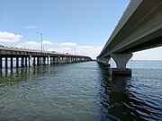 Highway (left) and pedestrian (right) bridges crossing the largest water channel through the causeway
 -
 View towards east (Tampa) from pedestrian trail bridge of the largest water channel cutting through the causeway
 -
 Free parking lot and one of the ten art-deco 'lounges' (left) along Hillsborough side of the trail
 -
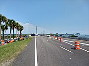 Construction on a new water channel and bridge near the eastern end of the causeway (April 2018)


References
- ^ "2012 Average Annual Daily Traffic Counts in Pinellas County" (PDF). Retrieved 28 October 2013.
- ^ a b "Corridor Story". Courtney Campbell Scenic Highway. Retrieved 29 October 2013.
- ^ a b Dunn, Hampton (November 1979). "Will its Original Name be Restored to Davis Causeway?". The Sunland Tribune. V (1): 33–40.
- ^ City of Tampa Parks and Recreation West Tampa Greenway Archived 2008-10-13 at the Wayback Machine Retrieved on 2010-04-29.
- ^ "SR 60 (Courtney Campbell Causeway) New Bridge Construction west of Ben T. Davis Beach 439206-1-52-01". FDOT Tampa Bay. Florida Department of Transportation. Retrieved 1 May 2018.
- ^ Hawley, Catherine (March 1, 2018). "Courtney Campbell upgrades cause traffic headaches". Fox 13 News. WTVT FOX 13. Retrieved 1 May 2018.
- ^ Leigh, Heather (February 20, 2018). "Project to improve Old Tampa Bay's water quality to cause Courtney Campbell Causeway lane closures". ABC Action News (WFTS-TV). Scripps Media. Retrieved 1 May 2018.
- ^ Rozyla, Lauren (June 20, 2017). "FDOT to cut hole in Courtney Campbell Causeway". ABC Action News (WFTS-TV). Scripps Media. Retrieved 1 May 2018.
External links
![]() Media related to Courtney Campbell Causeway at Wikimedia Commons
Media related to Courtney Campbell Causeway at Wikimedia Commons
Crossings of the Tampa Bay | ||||
|---|---|---|---|---|
| ||||
- 1934 establishments in Florida
- Bridges completed in 1934
- Bridges over Tampa Bay
- Buildings and structures in Clearwater, Florida
- Causeways in Florida
- Florida Scenic Highways
- Former toll bridges
- Road bridges in Florida
- Roads in Hillsborough County, Florida
- Roads in Pinellas County, Florida
- Roads in Tampa, Florida
- Transportation buildings and structures in Hillsborough County, Florida
- Transportation buildings and structures in Pinellas County, Florida