
Givat Ram: Difference between revisions
KolbertBot (talk | contribs) m Bot: HTTP→HTTPS |
Asparagusus (talk | contribs) m Reverted edits by 85.104.193.51 (talk) (AV) |
||
| (44 intermediate revisions by 34 users not shown) | |||
| Line 1: | Line 1: | ||
{{Short description|Neighborhood in Jerusalem, Israel}} |
|||
[[File:Israel museum.JPG|250px|thumbnail|right|Givat Ram]] |
|||
[[File:WikiAir_IL-13-06_021_-_Kiryat_HaMemshala.JPG|thumb|Aerial view of [[Kiryat HaMemshala]] on Givat Ram, with the [[Knesset]] in the lower right corner and the [[Supreme Court of Israel]] in the upper left corner]] |
|||
[[Image:Hutz.JPG|thumb|Ministry of Foreign Affairs]] |
|||
'''Givat Ram''' ({{lang-he |
'''Givat Ram''' ({{lang-he|גִּבְעַת רָם}}) is a neighborhood in central [[Jerusalem]]. It is the site of [[Kiryat HaMemshala]] ([[Hebrew language|Hebrew]]: קריית הממשלה, ''lit.'' Government complex), which includes many of Israel's most important national institutions, among them the [[Knesset]] (Israel's Parliament), the [[Israel Museum]] (as well as the private [[Bible Lands Museum Jerusalem|Bible Lands Museum]]), the [[Israeli Supreme Court|Supreme Court]], [[Bank of Israel]], [[Academy of the Hebrew Language]], [[National Library of Israel|National Library]], one of the campuses of the [[Hebrew University of Jerusalem]], and many government ministries' offices. |
||
==Etymology== |
==Etymology== |
||
Two versions: |
|||
| ⚫ | ''Ram'' is a Hebrew acronym for Rikuz Mefakdim – {{lang-he| |
||
| ⚫ | # ''Ram'' is a Hebrew acronym for Rikuz Mefakdim – {{lang-he|ריכוז-מפקדים}}, lit. ''officers' assembly'', therefore Giv'at Ram means ''Officers' assembly hill''.<ref>{{cite web|url=http://www.ybz.org.il/?ArticleID=1492 |title=Yad Ben Zvi website (Hebrew) |publisher=Ybz.org.il |access-date=2013-01-20}}</ref><ref>{{cite web |url=http://www.jerusalem.muni.il/english/sys/tour/vir_tour/show/show_tour.asp?tour_id=115 |title=Jerusalem Municipality website |publisher=Jerusalem.muni.il |access-date=2013-01-20 |url-status=dead |archive-url=https://web.archive.org/web/20120222045055/http://www.jerusalem.muni.il/english/sys/tour/vir_tour/show/show_tour.asp?tour_id=115 |archive-date=2012-02-22 }}</ref> |
||
# ''Ram'' is a Hebrew acronym for Rehavia Hamurhevet – {{lang-he|רחביה המורחבת}}, lit. expansion of [[Rehavia]], and there are maps and over evidence for the efforts to build this neighborhood in the 40's. <ref>{{Cite web |last=Hesse |first=Gilad |title=Facebook post |url=https://www.facebook.com/gilad.hesse/posts/pfbid0vWM2f |access-date=2023-04-26 |website=www.facebook.com |language=en}}</ref><ref>{{Cite web |title=אוניברסיטת בר-אילן |url=https://www.facebook.com/biu.info/posts/pfbid029TAY1Ze1uoxAgxkSqXACRkRFkAnFbyrx7LQurVaCjedVoVGHEVkEw5dFx87ETiQ1l |access-date=2023-04-26 |website=www.facebook.com |language=en}}</ref><ref>{{Citation |last=מלבסקי |first=עברית: אברהם |title=עברית: ירושלים - החוצב מכשיר את הקרקע להנחת היסודות לבתים הראשונים בשכונה החדשה של רחביה המורחבת, הנבנית על אדמת הקק"ל |date=1 March 1947 |url=https://commons.wikimedia.org/wiki/File:%D7%99%D7%A8%D7%95%D7%A9%D7%9C%D7%99%D7%9D_-_%D7%94%D7%97%D7%95%D7%A6%D7%91_%D7%9E%D7%9B%D7%A9%D7%99%D7%A8_%D7%90%D7%AA_%D7%94%D7%A7%D7%A8%D7%A7%D7%A2_%D7%9C%D7%94%D7%A0%D7%97%D7%AA_%D7%94%D7%99%D7%A1%D7%95%D7%93%D7%95%D7%AA_%D7%9C%D7%91%D7%AA%D7%99%D7%9D_%D7%94%D7%A8%D7%90%D7%A9%D7%95%D7%A0%D7%99%D7%9D_%D7%91%D7%A9%D7%9B%D7%95%D7%A0%D7%94_%D7%94%D7%97%D7%93%D7%A9%D7%94_%D7%A9%D7%9C_%D7%A8%D7%97%D7%91%D7%99%D7%94_%D7%94%D7%9E%D7%95%D7%A8%D7%97%D7%91%D7%AA,_%D7%94%D7%A0%D7%91%D7%A0%D7%99%D7%AA_%D7%A2%D7%9C-JNF040505.jpeg |access-date=2023-04-26}}</ref> |
|||
==History== |
==History== |
||
[[File:Givat ram entrance night 1.jpg|thumb|Edmond J. Safra Campus, Hebrew University of Jerusalem]] |
[[File:Givat ram entrance night 1.jpg|thumb|Edmond J. Safra Campus, [[Hebrew University of Jerusalem]]]] |
||
Before 1948, maps of the area drawn by the Survey of Palestine team tagged it as Karam es Sila. |
Before 1948, maps of the area drawn by the [[Survey of Palestine]] team tagged it as Karam es Sila. The name indicates it was a ''karam'' (grape field) belonging to the Sala (שלה might be originally סלע or سلع) family or the grape field near stone quarries. |
||
Before |
Before the [[1947–1949 Palestine war|1947–1949 Arab-Israeli war]], the area in the north was known by the Arabs as [[Sheikh Badr]]. In December 1949, the Israeli government, headed by [[David Ben-Gurion]], passed a resolution to build a government precinct in Jerusalem. Givat Ram, a hill in the west of the city, which had been an assembly point for the [[Gadna (Israel)|Gadna Youth Battalions]], was chosen for this purpose. The topography of the site was made up of three ridges, meshed with the idea of establishing three clusters of buildings – the government precinct, a university campus and a museum. {{Citation needed|reason=Previous source was a Google Search for the article's title|date=November 2021}}[[File:Jerusalem-Compiled,_drawn_and_printed_by_the_Survey_of_Palestine-1.jpg|thumb|Jerusalem, Produced by the [[Survey of Palestine]], 1945-1946]]The Knesset, Israeli government offices, and the Israeli Supreme Court are located in Givat Ram, as are cultural landmarks such as the Israel Museum, the Bible Lands Museum,<ref>{{cite web|url=http://www.israelnationalnews.com/News/News.aspx/135838 |title=Jewish Pride: Prime Minister's Son Wins Bible Contest |publisher=Israelnationalnews.com |access-date=2013-01-20}}</ref> the [[Bloomfield Science Museum]], a campus of the Hebrew University of Jerusalem,<ref>{{cite book|url=https://books.google.com/books?id=6x3S8eM3spAC&q=attacks+on+medical+convoys+to+mount+scopus&pg=PA193 |title=International dictionary of university histories: edited by Carol Summerfield and Mary Elizabeth Devine |isbn=9781884964237 |access-date=2013-01-20|last1=Summerfield |first1=Carol J. |last2=Devine |first2=Mary Elizabeth |last3=Levi |first3=Anthony |year=1998 }}</ref> the [[National Library of Israel]],<ref name=Haaretz>{{cite news |author = Aryeh Dayan |author-link = Aryeh Dayan |title = New chapter in a sad saga |publisher = [[Haaretz]] |url = http://www.haaretz.com/hasen/spages/919549.html |access-date=October 1, 2008 }}</ref> and [[Binyanei HaUma]] - The National Convention Center. |
||
| ⚫ | The northern part of the neighborhood, between the convention center and the university, where the government ministries are clustered, is officially known as [[Kiryat HaLeom]]. A new apartment project, Mishkenot Ha’uma, is being built in this area.<ref>{{cite web |url=http://www.jpost.com/LocalIsrael/InJerusalem/Article.aspx?id=192283 |title= A luxury we can't afford |author=Paul Widen |publisher=The Jerusalem Post |location=Jerusalem |date=October 22, 2010 |access-date=2011-06-13}}</ref> The [[Wohl Rose Garden]] is also located in the neighborhood. |
||
==High-Tech village== |
|||
The Knesset, Israeli government offices, and the Israeli Supreme Court are located in Givat Ram, as are cultural landmarks such as the Israel Museum, the Bible Lands Museum,<ref>{{cite web|url=http://www.israelnationalnews.com/News/News.aspx/135838 |title=Jewish Pride: Prime Minister's Son Wins Bible Contest |publisher=Israelnationalnews.com |date= |accessdate=2013-01-20}}</ref> the [[Bloomfield Science Museum]], a campus of the Hebrew University of Jerusalem,<ref>{{cite web|url=https://books.google.com/books?id=6x3S8eM3spAC&pg=PA193&lpg=PA193&dq=attacks+on+medical+convoys+to+mount+scopus&source=bl&ots=i3xSFCCEoQ&sig=OfknIC090FABGc6blXu_PbZtM80&hl=en&ei=d__gSan5I56RjAevpu3UDQ&sa=X&oi=book_result&ct=result&resnum=10 |title=International dictionary of university histories: edited by Carol Summerfield and Mary Elizabeth Devine |publisher=Books.google.com |date= |accessdate=2013-01-20}}</ref> the [[National Library of Israel]],<ref name=Haaretz>{{cite news |author = [[Aryeh Dayan]] |title = New chapter in a sad saga |publisher = [[Haaretz]] |url = http://www.haaretz.com/hasen/spages/919549.html |accessdate=October 1, 2008 }}</ref> and the [[Binyanei HaUma]] convention center. |
|||
The Givat Ram High-Tech Village was established jointly by the [[Jerusalem Development Authority]] and the Hebrew University. It is one of the first high tech parks in Israel built in proximity to centers of academic research. It provides a starting base for technological start-up companies.<ref>{{cite web|url=http://www.jda.gov.il/template/default_e.aspx?Cid=28|title=JDA - Development Of Employment And Industrial Parks|website=www.jda.gov.il|access-date=22 April 2018|archive-date=23 April 2018|archive-url=https://web.archive.org/web/20180423101850/http://www.jda.gov.il/template/default_e.aspx?Cid=28|url-status=dead}}</ref> |
|||
[[File:IL-Westjer-Kongr-zentr.jpg|thumb|Binyanei HaUma and hotel in Givat Ram]] |
|||
| ⚫ | The northern part of the neighborhood, between the convention center and the university, where the government ministries are clustered, is officially known as [[Kiryat HaLeom]]. A new apartment project, Mishkenot Ha’uma, is being built in this area.<ref>{{cite web |url=http://www.jpost.com/LocalIsrael/InJerusalem/Article.aspx?id=192283 |title= A luxury we can't afford |author=Paul Widen |publisher=The Jerusalem Post |location=Jerusalem |date=October 22, 2010 | |
||
==Archaeological findings== |
==Archaeological findings== |
||
The first salvage excavation was conducted before [[Binyanei HaUma]] was built, in July- August 1949, by M. Avi-Yonah, who unearthed hewn installations, cisterns and pools of various sizes dating to the Herodian period, bricks and tiles bearing stamps of the [[Legio X Fretensis|Tenth Roman Legion]], and the remains of a monastery. |
The first salvage excavation was conducted before [[Binyanei HaUma]] was built, in July- August 1949, by [[M. Avi-Yonah]], who unearthed hewn installations, cisterns and pools of various sizes dating to the Herodian period, bricks and tiles bearing stamps of the [[Legio X Fretensis|Tenth Roman Legion]], and the remains of a monastery. |
||
[[File:Israeli_Air_Force_Fly_By._Israel_73rd_Independence_Day,_April_2021._XIV.jpg|thumb|View of the [[Knesset]], on Givat Ram. [[Rehavia]] is on the background]] |
|||
In May–June 1968, before a new hotel (then the Hilton) was built south of Binyanei HaUma, Avi-Yonah conducted a second salvage excavation. He found remains of an oval-shaped potter's kiln, a preparation area for clay, and a deep water cistern. The area had been covered by a thick layer of plaster upon which were found large [[mortaria]] and many bricks, some bearing stamps of the Tenth Legion. |
In May–June 1968, before a new hotel (then the Hilton) was built south of Binyanei HaUma, Avi-Yonah conducted a second salvage excavation. He found remains of an oval-shaped potter's kiln, a preparation area for clay, and a deep water cistern. The area had been covered by a thick layer of plaster upon which were found large [[mortaria]] and many bricks, some bearing stamps of the Tenth Legion. |
||
During the work on a new international convention center east of Binyanei HaUma, a large salvage excavation was conducted in April–September 1992 on behalf of the [[Israel Antiquities Authority]], but roughly 60% of the parking lot area had already been dug up by bulldozers. |
During the work on a new international convention center east of Binyanei HaUma, a large salvage excavation was conducted in April–September 1992 on behalf of the [[Israel Antiquities Authority]], but roughly 60% of the parking lot area had already been dug up by bulldozers. |
||
In July 1993, a small excavation in the northwestern corner dismantled kilns of the Tenth Legion and lifted a [[mosaic]] floor of the [[Byzantine]] period.<ref> |
In July 1993, a small excavation in the northwestern corner dismantled kilns of the Tenth Legion and lifted a [[mosaic]] floor of the [[Byzantine]] period.<ref>{{cite web|url=http://www.fas.harvard.edu/~semitic/wl/publications/binyaneihauma.html|archive-url=https://archive.today/20120623024934/http://www.fas.harvard.edu/~semitic/wl/publications/binyaneihauma.html|url-status=dead|title=Binyanei Ha'Uma - The Shelby White - Leon Levy Program for Archaeolog…|date=23 June 2012|archive-date=23 June 2012|website=archive.is|access-date=22 April 2018}}</ref> |
||
== Photo gallery == |
|||
<gallery widths="170" heights="170"> |
|||
File:Israel museum.JPG|Aerial photograph of the [[Israel Museum]], with the [[Knesset]] in the background |
|||
File:Israel Supreme Court.jpg|[[Supreme Court of Israel]], with the [[Knesset]] on the background |
|||
File:Hutz.JPG|[[Ministry of Foreign Affairs (Israel)|Ministry of Foreign Affairs]], with the [[Bank of Israel]] in the background |
|||
File:The knesset illuminated.jpg|Knesset at Dusk |
|||
File:WikiAir IL-13-06 020 - Givat Ram.JPG|Aerial view of Givat Ram |
|||
</gallery> |
|||
==See also== |
==See also== |
||
* |
*[[Kiryat HaMemshala]] |
||
*[[Sheikh Badr Cemetery|Sheikh Bader cemetery]] or Givat Ram cemetery, Jewish Israeli cemetery used between 1948–1951 |
|||
==References== |
==References== |
||
{{Commons category| |
{{Commons category|Giv'at Ram}} |
||
{{ |
{{Reflist}} |
||
<imagemap> |
<imagemap> |
||
| Line 62: | Line 75: | ||
{{Neighborhoods of Jerusalem}} |
{{Neighborhoods of Jerusalem}} |
||
{{ |
{{Coord|31.78|N|35.20|E|scale:20000|display=title}} |
||
[[Category:Neighbourhoods of Jerusalem]] |
[[Category:Neighbourhoods of Jerusalem]] |
||
Latest revision as of 18:52, 24 April 2024

Givat Ram (Hebrew: גִּבְעַת רָם) is a neighborhood in central Jerusalem. It is the site of Kiryat HaMemshala (Hebrew: קריית הממשלה, lit. Government complex), which includes many of Israel's most important national institutions, among them the Knesset (Israel's Parliament), the Israel Museum (as well as the private Bible Lands Museum), the Supreme Court, Bank of Israel, Academy of the Hebrew Language, National Library, one of the campuses of the Hebrew University of Jerusalem, and many government ministries' offices.
Etymology[edit]
Two versions:
- Ram is a Hebrew acronym for Rikuz Mefakdim – Hebrew: ריכוז-מפקדים, lit. officers' assembly, therefore Giv'at Ram means Officers' assembly hill.[1][2]
- Ram is a Hebrew acronym for Rehavia Hamurhevet – Hebrew: רחביה המורחבת, lit. expansion of Rehavia, and there are maps and over evidence for the efforts to build this neighborhood in the 40's. [3][4][5]
History[edit]

Before 1948, maps of the area drawn by the Survey of Palestine team tagged it as Karam es Sila. The name indicates it was a karam (grape field) belonging to the Sala (שלה might be originally סלע or سلع) family or the grape field near stone quarries.
Before the 1947–1949 Arab-Israeli war, the area in the north was known by the Arabs as Sheikh Badr. In December 1949, the Israeli government, headed by David Ben-Gurion, passed a resolution to build a government precinct in Jerusalem. Givat Ram, a hill in the west of the city, which had been an assembly point for the Gadna Youth Battalions, was chosen for this purpose. The topography of the site was made up of three ridges, meshed with the idea of establishing three clusters of buildings – the government precinct, a university campus and a museum. [citation needed]

The Knesset, Israeli government offices, and the Israeli Supreme Court are located in Givat Ram, as are cultural landmarks such as the Israel Museum, the Bible Lands Museum,[6] the Bloomfield Science Museum, a campus of the Hebrew University of Jerusalem,[7] the National Library of Israel,[8] and Binyanei HaUma - The National Convention Center.
The northern part of the neighborhood, between the convention center and the university, where the government ministries are clustered, is officially known as Kiryat HaLeom. A new apartment project, Mishkenot Ha’uma, is being built in this area.[9] The Wohl Rose Garden is also located in the neighborhood.
High-Tech village[edit]
The Givat Ram High-Tech Village was established jointly by the Jerusalem Development Authority and the Hebrew University. It is one of the first high tech parks in Israel built in proximity to centers of academic research. It provides a starting base for technological start-up companies.[10]
Archaeological findings[edit]
The first salvage excavation was conducted before Binyanei HaUma was built, in July- August 1949, by M. Avi-Yonah, who unearthed hewn installations, cisterns and pools of various sizes dating to the Herodian period, bricks and tiles bearing stamps of the Tenth Roman Legion, and the remains of a monastery.

In May–June 1968, before a new hotel (then the Hilton) was built south of Binyanei HaUma, Avi-Yonah conducted a second salvage excavation. He found remains of an oval-shaped potter's kiln, a preparation area for clay, and a deep water cistern. The area had been covered by a thick layer of plaster upon which were found large mortaria and many bricks, some bearing stamps of the Tenth Legion.
During the work on a new international convention center east of Binyanei HaUma, a large salvage excavation was conducted in April–September 1992 on behalf of the Israel Antiquities Authority, but roughly 60% of the parking lot area had already been dug up by bulldozers.
In July 1993, a small excavation in the northwestern corner dismantled kilns of the Tenth Legion and lifted a mosaic floor of the Byzantine period.[11]
Photo gallery[edit]
-
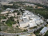 Aerial photograph of the Israel Museum, with the Knesset in the background
 -
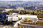 Supreme Court of Israel, with the Knesset on the background
 -
 Ministry of Foreign Affairs, with the Bank of Israel in the background
 -
 Knesset at Dusk
 -
 Aerial view of Givat Ram


See also[edit]
- Kiryat HaMemshala
- Sheikh Bader cemetery or Givat Ram cemetery, Jewish Israeli cemetery used between 1948–1951
References[edit]
- ^ "Yad Ben Zvi website (Hebrew)". Ybz.org.il. Retrieved 2013-01-20.
- ^ "Jerusalem Municipality website". Jerusalem.muni.il. Archived from the original on 2012-02-22. Retrieved 2013-01-20.
- ^ Hesse, Gilad. "Facebook post". www.facebook.com. Retrieved 2023-04-26.
- ^ "אוניברסיטת בר-אילן". www.facebook.com. Retrieved 2023-04-26.
- ^ מלבסקי, עברית: אברהם (1 March 1947), עברית: ירושלים - החוצב מכשיר את הקרקע להנחת היסודות לבתים הראשונים בשכונה החדשה של רחביה המורחבת, הנבנית על אדמת הקק"ל, retrieved 2023-04-26
- ^ "Jewish Pride: Prime Minister's Son Wins Bible Contest". Israelnationalnews.com. Retrieved 2013-01-20.
- ^ Summerfield, Carol J.; Devine, Mary Elizabeth; Levi, Anthony (1998). International dictionary of university histories: edited by Carol Summerfield and Mary Elizabeth Devine. ISBN 9781884964237. Retrieved 2013-01-20.
- ^ Aryeh Dayan. "New chapter in a sad saga". Haaretz. Retrieved October 1, 2008.
- ^ Paul Widen (October 22, 2010). "A luxury we can't afford". Jerusalem: The Jerusalem Post. Retrieved 2011-06-13.
- ^ "JDA - Development Of Employment And Industrial Parks". www.jda.gov.il. Archived from the original on 23 April 2018. Retrieved 22 April 2018.
- ^ "Binyanei Ha'Uma - The Shelby White - Leon Levy Program for Archaeolog…". archive.is. 23 June 2012. Archived from the original on 23 June 2012. Retrieved 22 April 2018.
