Otanche: Difference between revisions
Content deleted Content added
Milenioscuro (talk | contribs) No edit summary |
Milenioscuro (talk | contribs) m File renamed: File:Bandera de Otanche.svg → File:Flag of Otanche (Boyacá).svg File renaming criterion #6: Harmonize file names of a set of images to ease their usage in templates |
||
| Line 8: | Line 8: | ||
|imagesize = |
|imagesize = |
||
|image_caption = |
|image_caption = |
||
|image_flag = |
|image_flag = Flag of Otanche (Boyacá).svg |
||
|image_seal = |
|image_seal = |
||
|image_map = Colombia - Boyaca - Otanche.svg |
|image_map = Colombia - Boyaca - Otanche.svg |
||
Revision as of 04:51, 11 December 2012
Otanche | |
|---|---|
Municipality and town | |
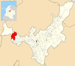
 Location of the municipality and town of Otanche in the Boyacá Department of Colombia. | |
| Country | |
| Department | Boyacá Department |
| Province | Western Boyacá Province |
| Time zone | UTC-5 (Colombia Standard Time) |
Otanche is a town and municipality in Boyacá Department, Colombia, part of the subregion of the Western Boyacá Province.

