
Åtorp
| Åtorp | ||||||
|
||||||
| State : | Sweden | |||||
| Province (län): | Örebro län | |||||
| Historical Province (landskap): | Varmland | |||||
| Municipality : | Degerfors | |||||
| Coordinates : | 59 ° 7 ' N , 14 ° 22' E | |||||
| SCB code : | S6038 | |||||
| Status: | Småort | |||||
| Residents : | 192 (December 31, 2015) | |||||
| Area : | 0.33 km² | |||||
| Population density : | 582 inhabitants / km² | |||||

Åtorp is a place ( Småort ) in the west of the Swedish province of Örebro län . He belongs to the municipality of Degerfors . The next larger towns are Degerfors to the north (16 km) and Svartå to the east (11 km); the nearest town is Karlskoga to the north (30 km).
geography
The larger, western part of Åtorp is in the historical province (landskap) Värmland , while the eastern part is in Närke . The border is formed by the Letälven river , which originates in Lake Möckeln near Degerfors and flows into the Skagern around 22 km south . In the center of the village, the Letälvsbron bridge runs over the river along Länsväg 204.
The surrounding landscape consists largely of forest-managed coniferous forests , fields and moors .
history
The first written mentions go back to the 15th century. At that time the river was called "Å", from which the place name "Åtorp" was later formed. Already at that time there were the first fords across the river. A small chapel, the Skogsbo chapel , stood near what is now the area where travelers could stop to pray against the dangers on the Letstigen, the medieval pilgrimage route between Kristinehamn and Örebro .
In 1638 the construction of the Nysunds kyrka began. The wooden church initially consisted of only a small part, which later formed the central nave. Two years later the church was consecrated by Superintendent Jonas Niclai Oriensulanus. The three-sided choir was added on the east side in 1683. From 1736 to 1738 the cross arms and the tower in the west were built. The ceiling painting was completed by the painter Peter Mård in 1747. The church was renovated in the 1840s.
The Letälvsbron bridge was built in 1817. On the east side of the bridge is the following inscription: "Må Gud hielp 1751 och hitintills har Gud hulpit." - Something like: "May God help 1751 and he has helped to this day." Historians agree that this inscription refers to one older wooden bridge from 1751, which is said to have stood a little further north. Rumor has it that the architect of the bridge killed himself after it was completed, fearing that it would collapse with the slightest load. The bridge is still in its original form, only the asphalt has been renewed. There is no weight limit for vehicles. Heavy trucks are now driving over the bridge to deliver to local companies. With a length of 98 meters, the Letälvsbron is the longest stone bridge in Örebro Län.
In 1931/1932 a hydroelectric power station was built south of the village and the Letälven was dammed to its present water depth. From 2006 to 2007 and 2009 it was rebuilt and expanded and now generates 34 GWh annually .
Before 2015, Åtorp had the status of a crime scene , but then lost it due to the excessive distance in the residential area according to the crime scene definition. The Småort , which has since been designated by the Statistiska centralbyrån , only includes the western, Värmland part of the place.

church

View from the water

At the power plant
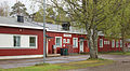
school

Construction of the Åtorp hydropower station in 1931/1932
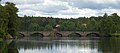
Bridge over Letälven


population
Population development

Individual evidence
- ↑ a b Statistiska centralbyrån : Småorter 2015, byggnader, areal, överlapp tatorter, coordinater (Excel file)
- ↑ Bron i Åtorp. Retrieved September 14, 2016 .
- ↑ Nysunds Kyrka. Retrieved September 14, 2016 .
- ↑ Letälvsbron. Retrieved September 14, 2016 .
- ↑ Stories from various residents
Perpetrator: Degerfors | Svartå
Småorter: Åtorp | Högberg östra | Knutsbol