
Eastern Bosphorus
| Eastern Bosphorus | ||
|---|---|---|
 |
||
| Connects waters | Peter the Great Bay | |
| with water | Amur Bay and Ussuri Bay | |
| Separates land mass | Muravyov Amursky Peninsula | |
| of land mass | Russky | |
| Data | ||
| Geographical location | 43 ° 4 '12 " N , 131 ° 54' 0" E | |
|
||
| length | 9 km | |
| Smallest width | 800 m | |
| Coastal towns | Vladivostok | |
| Islands | Russky , Elena | |
| bridges | Russky Bridge | |
 |
||

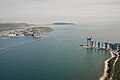
The Eastern Bosporus ( Russian Босфор Восточный , Bosfor Wostotschny ) is a strait in the Russian Primorye region and is located in the Peter the Great Bay in the Sea of Japan . The Eastern Bosporus separates the Muravjow-Amursky peninsula from the two islands of Russky and Elena . The strait connects Amur Bay in the west and Ussuri Bay in the east.
The Eastern Bosphorus is up to 50 meters deep, approx. 9 kilometers long and at its narrowest point only 800 meters wide.
The Russky Bridge , a cable-stayed bridge , connects the peninsula with the Russky Island. The bridge was opened in July 2012 and the ferry service across the strait was discontinued. With a span of 1,104 meters, it has been the longest cable-stayed bridge in the world since 2012.
Russky Bridge under construction

Russky Bridge

View of the Eastern Bosphorus from Vladivostok

View of the Russky Bridge over the Eastern Bosphorus
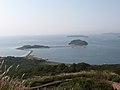
Russky Island


