Číčov (mountain)
| Číčov | ||
|---|---|---|
| height | 476.1 m nm | |
| location | Czech Republic | |
| Mountains | Central Bohemian Uplands | |
| Coordinates | 50 ° 27 '40 " N , 13 ° 48' 7" E | |
|
|
||
| Type | Kegelberg | |
| rock | basalt | |
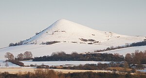
The Číčov , also Hořenecký Špičák (German Spitzberg , 476 m), is a striking mountain in the so-called Launer part of the Bohemian Central Mountains ( České středohoří ) in the Czech Republic . Because of its geological and floristic features, the Číčov Nature Reserve has existed since 1951 .
Location and surroundings
The Číčov is located about ten kilometers south of Bílina ( Bilin ) and ten kilometers east of Most ( Brüx ) in the Bohemian Central Uplands on the left Elbe. Immediately at the foot of the mountain are the small towns of Kozly ( Kosel ) and Hořenec ( Horzenz ). Neighboring mountains are the Dlouhá hora ( Gluha ), Svinky ( Zwinkenberg ) and Vraník ( Wranik ).
natural reserve
Since 1951 the Číčov has been a nature reserve under state protection on 5.61 hectares. An area characterized by dry grass is protected and is home to many rare heat-loving plants.
Protected plants typical of Číčov include: a. the endemic Bohemian pasque flower ( Pulsatilla pratensis bohemica ) and the common feather grass ( Stipa pennata ).
geology
The peak of Číčov is made of basalt . The occurrence of the mineral aragonite in crystalline form in its crevices and cavities is unique . The base of the mountain is formed by Cretaceous sediments.
Paths to the summit
There are no marked hiking trails leading to Číčov. The best starting point for a visit to the mountain is the small village of Hořenec. The ascent to the summit is possible along a narrow path on its east side.


