
Črni cal
|
Črni Kal San Sergio |
|||||
|
|||||
| Basic data | |||||
|---|---|---|---|---|---|
| Country |
|
||||
| local community | Twill | ||||
| Coordinates | 45 ° 33 ' N , 13 ° 53' E | ||||
| height | 265 m. i. J. | ||||
| surface | 1.5 km² | ||||
| Residents | 229 (2018) | ||||
| Population density | 153 inhabitants per km² | ||||
| Post Code | 6275 | ||||


Črni Kal ( Italian San Sergio ) is an Istrian village in southwestern Slovenia with about 230 inhabitants. It belongs to the municipality of Koper in the Primorska region .
geography

The village is located on the western slope of the terrain, where the high plateau of the Karst drops steeply to the coastal plain. Immediately to the east of the village there are rock faces that are popular with climbers , similar to those in the nearby Osp .
Due to its location, the place plays a crucial role in the flow of traffic from the Slovenian inland down to the Adriatic coast. Here the road 409 Kozina –Koper, the most important road connection between Ljubljana and the coast until the opening of the A1 motorway in 2004, meanders in long serpentines from around 420 m down into the Rižana valley just above sea level. Until the completion of the motorway along with the 87 m high Črni-Kal Viaduct, the place was therefore notorious for long traffic jams, especially in the summer months. The Prešnica – Koper railway also overcomes the Črni Kal step in a long serpentine.
With the motorway, the volume of traffic in town has significantly reduced. The Črni Kal driveway is about two kilometers west of the village.
history
Above today's village on the rock face are the remains of a fortification from the 11th century.
The parish church of Črni Kal is dedicated to St. Valentine . Due to its distinctive crooked campanile , it is a landmark of the place.
gallery
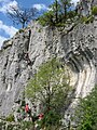
Climbers in Črni Kal

Church of St. Valentine on a postcard from 1913

