
Đồng Văn

| Đồng Văn | |||
|---|---|---|---|
|
|||
| Basic data | |||
| Country: |
|
||
| Province : | Ha Giang | ||
| ISO 3166-2: VN : | VN-03 | ||
| Coordinates : | 23 ° 16 ′ N , 105 ° 21 ′ E | ||
| Further information | |||
| Time zone : | UTC +7: 00 | ||

Dong Van is a Vietnamese village in the province of Hà Giang . It is located in a valley in the far north of the country, close to the Chinese border, at a height of almost 1100 m .
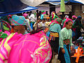
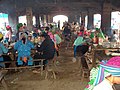
The village was founded around 1920 during the French colonial times as an outpost against China. A market hall complex, which forms the center of the town and is heavily frequented on market days, dates from this time.
population
Mainly ethnic minorities live in the region. They make up about 90% of the population and consist primarily of White Hmong and Red Dao . The Tay and Nung ethnic groups are also represented. The ethnic groups of the Giay and the Lo Lo are less common .
15 km south of Dong Van is the small village of Sa Phin . What is striking here is a relatively large fortress-like building complex. It is surrounded by a 2 meter high and almost 40 cm thick stone wall. The property was the residence of a powerful Hmong prince. The Hmong had a feudal social structure that was dependent on the feudal lord .
The nationally known Sunday minority markets in the nearby villages of Dong Vans and Mèo Vạcs are impressive .
In and around Đồng Văn, like Mèo Vạc, there are still remnants of the Chinese Tai-Kadai language , Quabiao (qa ° biau) . The exact meaning of this name is not known. It is a language that is spoken by a few people (300 to 400) in Vietnam and just as many in the border area of China in the Yunnan Province.
landscape
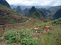
The landscape around Dong Van is one of the most attractive in Vietnam. Dense rainforests alternate seamlessly with light pine and cedar forests. Subtropical valleys with crops such as bananas and palm trees contrast with karst stone landscapes from which the farmers laboriously extract dry rice and cattle maize. The hills rise like "sugar loafs".
While corn is grown almost exclusively on the rocky slopes, there are rice terraces in the high valleys.
tourism
To travel to the regions north of Hà Giang requires a permit (police transit permit). You can get these for 10-25 US dollars (depending on the day of the week) in local hotels and police stations (as of 2009). Motorcycle tours through the Vietnamese mountain landscape are popular, with a stage from Đồng Văn to Mèo Vạc being particularly attractive. Self-governed hikes outside of paved paths are not permitted. Đồng Văn, however, has an extensive network of trails. To the north of Đồng Văn is an observation tower at a height of almost 1500 meters, which marks the northernmost point of Vietnam.
Global network of UNESCO geoparks
The dasng Văn karst plateau has been one of the member regions of the UNESCO regional development concept since 2010 .
photos

A market building in Dong Van
Filigree mountain landscape

Typical high valley
Representatives of the ethnic minorities in typical costumes
Lunch in the market hall complex

Soup made from horse entrails from a plastic bowl

Conversation among Hmong men


Individual evidence
- ↑ Roland Dusik, Vietnam
- ↑ John Colet, Vietnam handbook
- ^ Anthony Diller, The Tai-Kadai languages
- ^ Jan Dodd, Mark Lewis, Ron Emmons, Rough guide to Vietnam
- ↑ Colette Coleman, Planet Earth's Greatest Motorcycle Adventure Tours ( Memento from September 3, 2014 in the Internet Archive )
- ↑ Thousands of visitors to Dong Van karst plateau Geopark
literature
- Wolf-Eckart Bühler , Hella Kothmann: Vietnam - manual for individual discovery . 9th edition. Reise-Know-How-Verlag Rump, Bielefeld 2008, ISBN 978-3-8317-1720-0 .