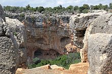
Aşağı Dünya
Coordinates: 36 ° 26 ′ 50.5 ″ N , 34 ° 0 ′ 35.3 ″ E
Aşağı Dünya ( Turkish for underworld , also Akhayat ) is a sinkhole with an adjacent ancient settlement in Rough Cilicia in southern Turkey.
location
The karst quarry is located in the Silifke district in the Turkish province of Mersin , about ten kilometers northeast of Silifke and 70 kilometers southwest of the provincial capital Mersin . There, the steep Yenibahçe Deresi valley stretches from the Mediterranean near the seaside resort of Atakent north into the mountainous hinterland. Parallel to this runs in the west from Atakent, the ancient Korasion , via İmamlı and Keşlitürkmenli to Uzuncaburç , the old Olba . You first pass the ruins of the ancient places Karadedeli, Karakabaklı and Işıkkale in the east. 600 meters after Işıkkale, a dirt road branches off to the right, which after about 800 meters reaches Aşağı Dünya, 400 meters west of the Yenibahçe Valley. On the further course of the road, the ancient settlement Kültesir is on the right, from where another path of about one kilometer leads to the Roman villa rustica Sinekkale .
description
The sinkhole is very similar to the two Koryk Grottoes (Cennet ve Cehennem) and the entrance of Kanytelleis (Kanlıdivane), both of which are not far, also in the area between the Limonlu and Göksu rivers , in ancient Lamos and Kalykadnos. It is oval and has a diameter of 100 meters in west-east and 150 meters in north-south, the depth is about 70 meters.
On the southern edge are the remains of houses from a settlement from the late Roman - early Byzantine period, another settlement with an area of 2.3 hectares is located 200 meters southeast of it. Some buildings are carved into the rock, remains of walls and door frames as well as a pressing system are still visible. One of the lintels bears four Olbic symbols . There are also columned altars with bust reliefs and inscriptions in the area, and chamosoria can also be seen.
literature
- Semavi Eyice : Some Byzantine small towns in the Rough Cilicia , in: 150 years of the German Archaeological Institute. Philipp von Zabern 1981 p. 208 ISBN 9783805304771 p. 207 plate 88.
- Friedrich Hild , Hansgerd Hellenkemper : Kilikien and Isaurien. Tabula Imperii Byzantini Volume 5. Verlag der Österreichischen Akademie der Wissenschaften, Vienna 1990, ISBN 3-7001-1811-2 , p. 199.
Web links
- Silifke Müzesi (Turkish)
Individual evidence
- ↑ Günder Varinlioğlu: Rural Habitat in the Hinterland of Seleucia ad Calycadnum during Late Antiquity In: Michael C. Hoff, Rhys F. Townsend (ed.): Rough Cilicia - New Historical and Archaeological Approaches Oxford 2013 ISBN 978-1-84217-518 -7 p. 202


