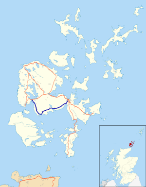
A964 road
| A964 road in the UK | |
| map | |
| Basic data | |
| Operator: | |
| Start of the street: |
Kirkwall ( 58 ° 59 ′ N , 2 ° 58 ′ W ) |
| End of street: |
Stenness ( 58 ° 59 ′ N , 3 ° 15 ′ W ) |
| Overall length: | 24.4 km (15.2 mi ) |
| The A964 at Clestrain Sound | |
The A964 road is an A-road on the Scottish Orkney island of Mainland .
course
The road branches off the A963 in the south of the island's capital, Kirkwall . It runs in a south-westerly direction along the coastline of Scapa Bay and connects with numerous hamlets and farms. Further to the southwest, the A964 runs through the villages of Greenigoe and Orphir and reaches its southernmost point near the ferry terminal to the islands of Hoy and Flotta . From this point it follows the coastline of Clestrain Sound to the northwest. West of Stenness at the head of the Loch of Stenness , the A964 joins the A965 (Kirkwall - Stromness ) after a total length of 24.4 km .
Surroundings
Along the way are the ruins of the medieval round church of Orphir , which are protected as a Category A monument. In the west it connects to the Hall of Clestrain residential building, which is also listed . Near Kirkwall, the road passes the Cairn of Crantit and the Scapa whiskey distillery .
Individual evidence
- ↑ Listed Building - Entry . In: Historic Scotland .
- ↑ Listed Building - Entry . In: Historic Scotland .

