
Aach (Dornstetten)
|
Ah
City of Dornstetten
|
|
|---|---|
.png) |
|
| Area : | 3.89 km² |
| Residents : | 1324 (2011) |
| Population density : | 340 inhabitants / km² |
| Incorporation : | 1st January 1975 |
| Postal code : | 72280 |
| Area code : | 07443 |
Aach is a district of Dornstetten in the Freudenstadt district on the eastern edge of the northern Black Forest. Until the end of 1974 the place was an independent municipality.
Surname
The place was called "Aha" in the early Middle Ages, from the 16th century "the Ahe" and also "in the Ahe". The old high German word "Aha" means flowing water, in Latin "aqua" (water). The syllable "ach" appears in many place names in the region, all of which are located on smaller rivers, such as B. Wolfach, Schiltach, Haßlach, Hausach, Biberach.
Waters
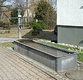
In Aach, Ettenbach, Kübelbach and Stockerbach unite to form the Glatt , which flows into the Neckar in Neckarhausen . In Aach, the three streams were dammed up in two ponds , in which logs were tied together to make rafts , which were then transported to the Neckar and beyond. The pond between the church and the Weiherweg was used for this until the end of the 19th century, the second a little below the current sports field was given up earlier. Aach was always well supplied with drinking water. Today there are still 8 wells, the troughs are partly made of sandstone and partly made of cast iron riveted plates.

Fountain in Aach on Brunnenstrasse

Well in Aach in the main street at the junction to Grüntal, from 1892

Fountain in Aach, in the main street, diagonally opposite the church
Fountain in Aach at the intersection

Well in Aach at the exit to Glatten


history
In a deed of donation from Emperor Heinrich II from 1150, Aach is given to the Bamberg Monastery. The Bambergers gave Aach to the Dukes of Zähringen as a fiefdom, but from 1348 the Kniebis Monastery also had possessions in Aach.
For several centuries, Aach was the seat of the "Waldgedings" , a community that included Aach, Benzinger Hof, Dietersweiler, Dornstetten, Grüntal, Hallwangen, Untermusbach and Wittlensweiler. In today's Gasthaus Waldgericht, formerly Gasthaus zur Sonne, they met several times a year to clarify all disputed questions. The new construction of the road from Freudenstadt towards Stuttgart in 1838 and the Freudenstadt - Stuttgart railway line, which went into operation in 1879, were of great importance for the place, even if the railway line meant the end of rafting across the Glatt.
It is doubtful whether the " Roman road " leading up the slope to Dornstetten was actually built by the Romans. However, 30 Roman bronze coins were found there in 1816.
On the Silberberg, east of the town center, small amounts of lead, copper and barium sulfate could be extracted in an opencast mine , but only the mining of barium was profitable until the middle of the 19th century.
Life in the 19th century
In a book of the "Royal Statistical-Topographical Bureau" from 1858 it says u. a .: “The inhabitants of Aach are physically strong, hardworking and orderly people, whose main sources of income are agriculture, cattle breeding, forest work, timber wagons and rafting. The largest holdings are 85 acres , but the common one is 10-15 acres. Two farms and 2 mills are to be mentioned as larger trades .....
Agriculture is carried out diligently and prudently; Improved farm equipment is only used by individuals and the fertilizer facilities leave a lot to be desired. Needle litter and sawdust are used for manure, and hall earth and ash are often used to improve the fields . It is preferred to grow spelled, oats, potatoes, hemp and flax. The produce of the field is not sufficient for the local needs, so that grain still has to be bought from outside. Fruit cultivation is mediocre and is mainly limited to late must varieties, but the resigned official notary Walther, who has contributed a lot to the improvement of agriculture, has also planted finer varieties such as Goldparmene, various Reinetten and other dessert fruit varieties with good success. Cattle-breeding, which, with the exception of an economist who breeds Simmenthal crossbreeds, deals with an ordinary landrace, is in a mediocre state. A local citizen keeps 2 breeding animals, for which the municipality gives him the use of 3 acres of meadows and 59 fl annually. The trade in cattle is not inconsiderable. "
Attractions
Border posts
The borders of the formerly independent place to the neighboring communities Dietersweiler, Wittlensweiler, Grüntal and Dornstetten were marked with cast iron border signs on red and black striped stone posts. Only the original Genzpfahl between Aach and Grüntal is still preserved. The others were restored, although no cast plates with raised letters were attached to the piles , but printed metal plates.

Aach - Grüntal border post

Aach - Dornstetten border post

Aach - Dietersweiler border post


Hour stone
In the Römerstraße at the northern exit of the town there is an hour stone that shows the distances in hours, to Pfalzgrafenweiler 2½ hours, to Stuttgart 20 hours and to Freudenstadt 1½ hours. 1 hour corresponded to a distance of 3725 m.

Waldgericht Inn
The impressive half-timbered building was built in 1428 as the "Gasthaus zur Sonne" and in 1633 it was renewed and enlarged. It used to be the official seat of the Waldgeding .
coat of arms
The municipal coat of arms shows a green branch with 5 leaves on a white background and in front of it the red "oath hand", with which reference is made to the judiciary within the Waldgeding .
Individual evidence
- ^ Federal Statistical Office (ed.): Historical municipality directory for the Federal Republic of Germany. Name, border and key number changes in municipalities, counties and administrative districts from May 27, 1970 to December 31, 1982 . W. Kohlhammer, Stuttgart / Mainz 1983, ISBN 3-17-003263-1 , p. 492 .
- ↑ http://wiki-de.genealogy.net/Aach_(Dornstetten)
- ↑ a b c d Description of the Oberamt Freudenstadt, published by the Royal Statistical-Topographical Bureau, 1858, Verlag Karl Aue, Stuttgart, pp. 169–172
- ↑ http://www.dornstetten.de