
Aarhus Bugt
| Aarhus Bugt | ||
|---|---|---|
| Waters | Kattegat | |
| Land mass | Jutland | |
| Geographical location | 56 ° 7 ' N , 10 ° 21' E | |
|
||
| surface | 150 km² | |
| Greatest water depth | 50 m | |
| Islands | no | |
| Tributaries | Aarhus Å | |

The Aarhus Bugt ( German Aarhus Bay ) is an approximately 150 km² large body of water in the southwestern Kattegat , which lies in front of the east Jutian city of Aarhus .
In the north it borders with the bays Kalø Vig and Begtrup Vig on the peninsulas Skødshoved and Helgenæs , which are both parts of the Mols landscape in southern Djursland . In the southeast the border is at the sandbank Mejl Flak and the islands of Samsø and Tunø . The northern end of the east-west passage between Mols and Samsø or Tunø is marked by the Sletterhage Fyr lighthouse at the southernmost point of Helgenæs. In the west, the bay extends to the Norsminde Fjord near Norsminde .
The bay reaches depths of up to 50 meters, which are mainly close to the cliffs south of Aarhus. On the coast in the south near Norsminde and north of the Aarhus district of Risskov are bathing beaches that are joined by summer house settlements.
The largest port on the bay is Aarhus Havn , which is also the second largest port and the largest container port in Denmark. It was created on the around 40 km long Aarhus Å watercourse flowing into the bay .

Aarhus Bay on a map from the Aarhus Office from 1826
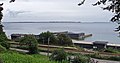
View from the Riis Skov forest with the Skødshoved and Helgenæs peninsulas in the background

Begtrup Vig Bay with the Skødshoved and Helgenæs peninsulas on the north bank of Århus Bay


Individual evidence
- ↑ a b Den Store Danske : Aarhus Bugt , accessed on August 7, 2014 (Danish)
- ↑ Den Store Danske: Aarhus Havn , accessed on January 26, 2012 (Danish)