Begtrup Vig
| Begtrup Vig | |
|---|---|
|
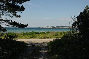
Begtrup Vig, taken from the north coast (Kamillevej) with a view over the Vig to Skødshoved. |
|
| Waters | Aarhus Bay |
| Land mass | Mols |
| Geographical location | 56 ° 9 '26 " N , 10 ° 28' 16" E |
| width | approx. 5 km |
Begtrup Vig is a Danish bay in the Baltic Sea on the north shore of Århus Bay on the coast of the Mols landscape on the Djursland peninsula . In the east the bay is bounded by the isthmus of Dragsmur and the Helgenæs peninsula , in the west by Skødshoved with the southernmost point Mols Hoved . It is named after the village of Begtrup on the shore and the Danish word Vig for small bay .
The bay is part of Natura 2000 area 51 Begtrup Vig og kystområder ved Helgenæs . The eastern part of the bay on the imaginary line from Strands to the western tip of Helgenæs has been part of the Mols Bjerge National Park since 2008 .
There are numerous summer houses on the northern shore of the bay, which has a narrow sandy beach. In the eastern part, on the north coast of Helgenæs, there is a small marina in Kongsgård .
Web links
Individual evidence
- ↑ Map of the Mols Bjerge National Park ( Memento of the original from October 28, 2011 in the Internet Archive ) Info: The archive link was automatically inserted and not yet checked. Please check the original and archive link according to the instructions and then remove this notice. , Danmarks National Park, accessed August 30, 2011

