
Helgenæs
Coordinates: 56 ° 8 ' N , 10 ° 32' E

As a small peninsula on the southern edge of Mols, Helgenæs is identical to the parish of Helgenæs Sogn . The Helgenæs peninsula is in turn part of the Djursland peninsula in eastern Jutland in Denmark . Helgenæs juts out into Århus Bay . The peninsula is part of Natura 2000 area 51 Begtrup Vig og kystområder ved Helgenæs , and the north-west coast has been part of the Mols Bjerge National Park since 2009 .
geography
Helgenæs covers a land area of around twenty square kilometers. The landscape was created around 12,000 years ago at the end of the last ice age . The ice on Jutland had almost melted when two tongues of ice slid over Mols as a result of another cold snap. The glaciers left a chain of hills of sand and gravel, today's Mols Bjerge. Larger lumps of ice remained and only melted slowly. This so-called dead ice formed dead ice holes with steep slopes.

Stødov Church 13th century, renovated in 1773

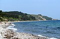
Helgenæs, view from Begtrup Vig

The Rye ski jumps near Dragsmur
Bursklint
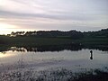
A lake in the north-west of Helgenæs

View from Ellemandsbjerg, Helgenæs

Sletterhage lighthouse.

Helgenæs and the Begtrup Vig map around 1900


The narrowest part of the peninsula is at about 240 m of the Isthmus of Dragsmur . This is said to have served the Vikings as a portage point for their long boats and saved them a 4 nm sailing route.
The villages of Kongsgårde , Borup, Ørby, Esby and Fejrup are on Helgenæs.
history
The name Helgenæs comes from the Danish word hellig (holy) and næs (headland) and was mentioned in a document in 1231 as "Hælghænæs". According to legend, sacrifices were made to the Nordic gods on the 99 m high Ellemandsbjerg . In 1773 Stødov Kirke, built in the 13th century, was renovated.
At the isthmus of Dragsmur , which connects Helgenæs with Mols, entrenchments were built during the German-Danish War (1848–1850) . The Danish troops were disembarked from this refuge on Helgenæs in 1849 and used in the Battle of Fredericia . Before that, they had been driven onto the peninsula by the Prussian army under the direction of General Olaf Rye .

traffic
Bus route 361 connects Helgenæs with Rønde every hour from 5 a.m. to 6 p.m. on weekdays . The line runs counterclockwise across the peninsula.
In front of Kongsgård in Begtrup Vig there is a small marina with a jetty, a generally accessible facility of an Aarhus sailing club. The Marguerite Route leads over Helgenæs .
Attractions
- Bo Bendixen Gallery in Ørby
- Ellemandsbjerg (99 m), offers a wide view of the national park
- Rye ski jumps near Dragsmur named after Olaf Rye
- Sletterhage Fyr , lighthouse from 1894 on the southern tip of Helgenæs
- Stødov Kirke and a small local history museum
- Tyskertårnet, a watchtower ruin east of Sletterhage Fyr from the time of the German occupation of Denmark in World War II (1940-1945)
Web links
Individual evidence
- ↑ Map of the Mols Bjerge National Park ( Memento of the original from February 24, 2014 in the Internet Archive ) Info: The archive link has been inserted automatically and has not yet been checked. Please check the original and archive link according to the instructions and then remove this notice. , Danmarks National Park, accessed August 30, 2011
- ↑ Helgenæs ( Danish ) denstoredanske.dk. Retrieved March 27, 2014.
- ^ Aage Houken: Håndbog i danske stednavne , Gyldendalske Boghandel 1976, ISBN 87-01-31021-6 , pp. 114, 179, 182
- ^ Liber Census Daniæ
- ↑ BoBendixen.dk ( Memento of the original from June 3, 2014 in the Internet Archive ) Info: The archive link was inserted automatically and has not yet been checked. Please check the original and archive link according to the instructions and then remove this notice. , Bo Bendixen. Last accessed February 2010.