
Acaill
| Acaill | ||
|---|---|---|
 |
||
| Waters | Atlantic Ocean | |
| Archipelago | British Islands | |
| Geographical location | 53 ° 58 ′ N , 10 ° 0 ′ W | |
|
||
| surface | 146 km² | |
| Highest elevation |
Croaghaun 688 m |
|
| Residents | 2569 (2011) 18 inhabitants / km² |
|
| main place | Gob to Choire | |

Acaill (also Oileán Acla ; anglicized Achill Island ) is an island in County Mayo and with 146 km² the largest island in Ireland apart from the main island. 2569 people live on Acaill (as of 2011). Around 87 percent of the island is covered by peat bogs . The island is connected to the mainland of the An Corrán peninsula via the Michael Davitt Bridge (near the village of Gob an Choire in the east of the island) .
Some attempts have been made in the past to promote industry on the island, but to date the main source of income is tourism, which developed between 1960 and 1970. The island's Gaelic football field and a secondary school are on the mainland near the town of Polranny.
history
It is believed that between 4000 and 3000 BC Around 500 to 1000 people lived on Acaill. An oar that was found near the Crannóg by Dookinella comes from a later period . Before the Neolithic settlers began farming, Acaill was probably mostly covered by forests. Settlement of the island increased during the Iron Age - small fortifications on the coast date from this time.
Grace O'Malley maintained a castle at Kildavnet ( Kildavnet Tower , Irish Túr Chill Dhamhnait ) on the island in the 16th century . In the 17th and 18th centuries there was a large migration from mainland Ireland (mostly from Ulster ) to Acaill due to the Ulster Plantation .
As a result of this immigration, two dialects were spoken on Acaill in the 19th century, which led to the fact that the places were listed with two different names in the 1824 census. Even today you can still find different names of individual places on maps.
Attractions
Keel East is a megalithic complex that was built during the 4th and 3rd millennium BC. BC in the Neolithic on Acaill.
Keem Bay
Keem Bay (Irish Trá na Coime ) in the far west near Achill Head is one of the most beautiful beaches in Ireland. You can reach it via a winding descent. It is nestled between 198 m and 450 m high hills and is also used for surfing. The headland south of Keem Bay ends in Moytoge Head , on which a British guard station from the First World War still stands today, which was used to prevent arms deliveries to the IRA .
If you want to take a look at the highest cliffs in Ireland ( Cliffs of Croaghaun ) , which have not yet been developed for tourism , you have to take the rather steep ascent (without designated paths) on the grassy Achill Head.
- Achill Island
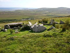
Neolithic tomb on Acaill

Crannóg Dookinella on Acaill

"Our Escort Into Glenaragh", diary sketch by Elizabeth Thompson , around 1909.
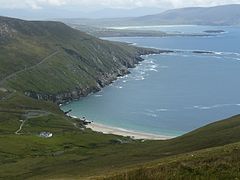
Keem Bay

Cliffs at Achill Head in the far west of the island

Two houses in the Deserted Village

Mass Rock on Keem Bay


Atlantic Drive
The Atlantic Drive (Irish Bóthar an Atlantaigh ) in the south and west of the island offers many impressive, sometimes very wind-prone viewpoints of the island, bays and the surf of the Atlantic, such as Camport Bay , a bay southeast of Dumha Éige .
Deserted Village
The ruined village of Deserted Village (Irish Baile Tréigthe ) is located in the north on the foothills of the 671 m high Slievemore . It was abandoned in the 19th century as a result of the great famine in Ireland (1845–1849). The still-preserved walls of the village, which comprises around 100 stone houses, give a small insight into the living conditions of the Irish rural population at that time. However, new research suggests that the village was only used in the summer as part of transhumance - in the fall, residents returned with their cattle to areas near the ocean (such as Dooagh or Pollagh). To the west of the village is an old British Genoese tower that was used as a watchtower against a French invasion. In the area is the 5000 year old Neolithic Court tomb Doogort West and the Sacred Spring of Keel East. The Loughannascaddy Crannóg is only four kilometers away.
Acaill Beag
Acaill Beag (German: Klein-Achill ) is a small island south of Acaill. In 1965, all residents of Acaill Beag were relocated to Acaill and the surrounding area on the mainland. The largest settlement was in the center of the island, framed by two mountains in the north and south of the island. There are a few holiday apartments on Acaill Beag, but they are rarely inhabited. The island can only be reached by sea and by prior arrangement from An Chloch Mhór.
At the southern tip of Acaill Beag is a lighthouse that was built in 1965.
Achilles henge
As Achill-henge is called a massive round of 30 concrete about four feet tall columns of more than 100 m circumference at Stonehenge recalls. It was built in November 2011 by local contractor and activist Joe McNamara as a tomb for the Celtic tiger . Since there was no planning permit for the structure, he has since been sentenced to remove the building, which had not yet happened in May 2015.
Dooagh Beach
In 1984 the sand on Dooagh Beach was washed away by strong storms. From then on, stones and rocks shaped the strip between the town and the sea. In mid-April 2017, the stones were covered with sand from the sea during a cold snap and an unusually strong wind. For almost two years, Dooagh again had a sandy beach about 300 meters long, which led to a short-term increase in tourism. In January 2019, the beach was washed back into the sea during a winter storm.
Recordings from 1890 show that the beach was also sandless back then. The washing up and removal of sand on this stretch of coast is therefore a recurring event.
economy
Although there have been a number of attempts to locate smaller industrial establishments, the economy is still largely based on tourism, which had developed strongly in the 1960s and 1970s. During the 19th and 20th centuries, residents of Acaill received a subsidy if they and their families stayed on Acaill despite working abroad in order to strengthen this remote region. The economic boom in Ireland opened up more opportunities to find work on the island or in the surrounding area. Agriculture and livestock (mainly sheep) play because of the proliferation of peat bogs on the island only a subordinate role and are worthwhile only because of EU - subsidies .
Fishing, once a significant part of the economy, is also becoming less and less important, with the island being very famous among sharks in the past. The basking shark in particular was hunted here for its trans .
There are the following larger settlements on the island: Gob an Choire , Keel , Dooagh , Dooega , Doogort , An Caiseal , Dún Ibhir and Bun an Churraigh .
Famous residents
Estate manager Charles Cunningham Boycott (1832-1897), on whom the term boycott goes back, lived here.
The painter Paul Henry (1877–1958) lived on the island from 1910 to 1919. Some of his most important works, especially landscape paintings, were created here.
Even Heinrich Boell visited the island in his vacations in the 1950s and 1960s. The Irish Diary was created during this time. The Ruined Village Deserted Village Boll described in the fifth chapter ( "skeleton of a human settlement"). In 1958, Böll bought a house on the island, which is now made available to artists by the local Achill Heinrich Böll Association for a few weeks to work there. Visiting this house is expressly prohibited in order not to disturb the respective scholarship holder. According to Judith Hermann , who was there, there is not only great seclusion but also a bookshelf with works by all authors who have ever worked there before.
literature
- Jonathan Beaumont: Achillbeg - The Life of an Island . Oakwood Press, 2005, ISBN 0-85361-631-0
- Theresa McDonald: Achill Island - Archeology, History, Folklore . IAS Publications, 1997 (new edition 2006)
- JH Brennan: A guide to megalithic Ireland Aquarian Press 1994 ISBN 1-85538-270-9 p. 33
Web links
- visitachill.com Website of the local tourist office (English)
- goachill.com - German travel information about Achill Island
- Kieran Cooke: Achill-henge: A monument that divides Ireland. In: BBC News Magazine. February 16, 2012 (English).
Individual evidence
- ↑ Table No. 11 Population of inhabited Islands off the coast, 2006 and 2011 . In: Central Statistics Office (Ed.): Population Classified by area . Dublin 2012, p. 132 f .; cso.ie ( Memento from October 10, 2012 in the Internet Archive ; PDF; 3.6 MB)
- ↑ Anglo Avenger's Achilles antics The Mayo News, November 29, 2011th
- ↑ Anglo Avenger ordered to take down Achill-henge The Mayo News, March 15, 2012.
- ↑ Mayo developer erects statue in London city as a form of protest The Journal, May 5, 2015.
- ↑ Beach on Achill Island disappears following heavy storms , Raidió Teilifís Éireann, article from January 11, 2019, accessed on February 12, 2020.
- ↑ The Beach Miracle by Dooagh Tagesschau, accessed July 30, 2017.
- ↑ Irish beach washed away 33 years ago reappears overnight after freak tide , The Guardian, accessed July 30, 2017.
- ↑ See information from J. Hermann at the Frankfurt Book Fair, Deutschlandfunk , October 10, 2014, 10:25 am