Achterwehrer shipping canal
Coordinates: 54 ° 20 ' N , 9 ° 58' E
| Achterwehrer shipping canal | |
|---|---|
|
Achterwehrer Schifffahrtskanal north of the A 210 motorway bridge |
|
| location |
Germany Schleswig-Holstein District Rendsburg-Eckernförde Amt Achterwehr |
| length | 2.94 km |
| Built | 1913 |
| class | unclassified |
| Beginning | Upper Eider |
| The End | Kiel Canal (km 85.63) |
| Descent structures | Strohbrück (closed in 2001) |
| Ports | Flemhude |
| Junctions, crossings | Flemhuder Au Melsdorfer Au |
| Kilometrage | km 0.18 (NOK) to km 3.12 (Eider) |
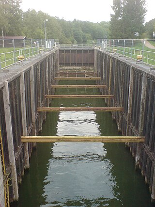
| Strohbrück lock chamber, view to the south to the Oberhaupt with hinged gate, 2009 | |
The Achterwehrer Schifffahrtskanal ( AwK ) is an approximately three kilometer long branch canal in the Achterwehr office in the Rendsburg-Eckernförde district in Schleswig-Holstein . It has been connecting the Eider with the Kiel Canal (NOK) since 1913 and, as a federal waterway, belongs to the NOK. The shipping route regulations therefore also apply to it . The canal is the responsibility of the Kiel-Holtenau Waterways and Shipping Office .
history
The construction of the Kiel Canal (contemporary Kaiser Wilhelm Canal ) from 1887 to 1895 resulted in a lowering of the water level of Lake Flemhuder by around seven meters. The new canal replaced the Eider Canal , the bottom of which was considerably higher. In order to prevent the groundwater level in the surrounding area from falling, a ring canal with a connection to the Eider was created, which was supposed to guarantee the original water level of 6.5 meters above sea level . However, adverse building ground prevented the western part from being built.
The Achterwehr and Flemhude lost their navigable connection with the Kiel Canal due to the deposition of excavated soil in the Flemhuder See in the course of the expansion of the Kiel Canal between 1907 and 1914. As an alternative, the eastern part of the ring canal was extended as the Achterwehrer shipping canal to the Kiel Canal and upgraded to a floor width of twelve meters and a depth of three meters.
Strohbrück lock
The Strohbrück lock (40 m usable length, 8 m width) overcame the difference in height of around seven meters from the Achterwehr shipping canal to the Kiel Canal .
The Obereider, which previously flowed into the Flemhuder See, was directed into the Achterwehrer Schifffahrtskanal and since then has flowed, reinforced by the Flemhuder Au and Melsdorfer Au , east of the lock through a weir over a weir into the Kiel Canal. A power plant was installed next to the weir.
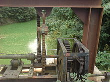
In 2001 the lock was decommissioned in order to save the high costs of an upcoming renovation. The lower gate ( Stemmtor ) has since been out of order and open, so that the aqueous humor level corresponds to that of the Kiel Canal. The upper gate ( folding gate ) is closed and blocks the lock against the Achterwehr shipping canal. This means that passage from and to the Kiel Canal is no longer possible. For safety reasons, the lock system is surrounded by a high fence. Pedestrians and cyclists can cross the canal via a bridge over the lower head of the lock. This bridge was originally designed as a roller bridge so that ships with high masts could also use the lock.
Use and shutdown
In the first decades of its existence, the canal was used intensively by commercial shipping, especially for transporting grain. With the structural change in agriculture and transport, the waterway lost its importance and was almost exclusively used for recreational water sports.
There is a lively leisure activity on the canal by paddlers and anglers. Paddlers can use an approximately 50 meter long transfer point at 54 ° 19 ′ 55.6 ″ N , 9 ° 57 ′ 55.4 ″ E to the Flemhuder See in order to get into the Kiel Canal. The Achterwehrer Schifffahrtskanal is operated by the fishing club SV Ringkanal Kiel e. V. manages.
Landscape protection area
The headland Flemhuder See / Ringkanal is a landscape protection area of 34.7 hectares.
literature
- M. Eckoldt (Hrsg.): Rivers and canals, The history of the German waterways . DSV-Verlag, 1998
- Rainer Lagoni: Kiel Canal 1895–1995: Festschrift . Wachholtz, Neumünster 1995, ISBN 3-529-05319-8
Web links
Individual evidence
- ↑ a b c d Federal Waterways and Shipping Administration: Lengths (in km) of the main shipping routes (main routes and certain secondary routes) of the federal inland waterways ( Memento from January 21, 2016 in the Internet Archive )
- ↑ wsv.de ( Memento of March 2, 2014 in the Internet Archive ), assignment of the federal inland waterways serving general traffic to the waterway classes; PDF (46 kB)
- ↑ Directory E, serial no. 38 der Chronik ( memento from July 22, 2016 in the Internet Archive ), Federal Waterways and Shipping Administration
- ↑ Homepage SV Ringkanal Kiel e. V. Accessed April 16, 2020 .
- ↑ State government of Schleswig-Holstein PDF (83 kb): List of the existing landscape protection areas. Archived from the original on May 17, 2014 ; accessed on June 17, 2019 .


