Adinkerke


Adinkerke is a Belgian town located three kilometers south-east of the North Sea coast , on the border with France and now part of the westernmost Belgian coastal town of De Panne . In 2014 the town, which belongs to the province of West Flanders, had around 2500 inhabitants.
Adinkerke is connected to De Panne by a road, the Kerkstraat, and a tram line, which cut through the Calmeynbos dune forest in a north-south direction. The tram line is the Kusttram , the longest tram line in the world, which connects all places along the entire Belgian coast and which has been extended south from De Panne to Adinkerke. The train station is connected in Adinkerke and further south the Plopsaland amusement park belonging to Adinkerke .
France can be reached via the French coastal town of Bray-Dunes via the Adinkerke train station , as can Brussels inland.
Adinkerke is connected to Dunkirk via the Neuwpoort-Dunkerque Canal . South of the canal, the N39 road runs, in France as D 601, between the two French neighboring towns of Adinkerke, namely the coastal town of Bray-Dunes and Ghyvelde, to Dunkirk.
Adinkerke is also connected to Bray-Dunes by the N389, in France further than D60, which runs south of the coastal dune belt De Westhoek / Dune du Perroquet .
A lower street also connects Adinkerke directly with Ghyvelde.
Immediately south of Adinkerke, the European route 40 from Belgium to France runs parallel to its coast to Calais . The exit of the E 40 in Adinkerke leads to the N34, which leads through the middle of Adinkerke and on through the Calmeynboos dune forest to De Panne.
As the first Belgian town that can be reached from the French North Sea coast, the town benefits from tax differences in tobacco tax between France and Belgium.
geology
The place is mainly in the fertile polder area . Only between Adinkerke and Ghyvelde is an approximately 500-meter-wide, 5000-year-old dune belt that is called Cabourduinen in the Belgian part and the Ghyvelde Fossil Dunes in France .
history
The oldest human settlement found so far in Adinkerke goes back to the 5th century BC. Traces have also been found from Roman times. At the end of the 7th century, during the Merovingian era, a flourishing settlement emerged that continued to exist in the Carolingian era . It is unclear whether the settlement can be assigned to the name Isera Portus, which has been handed down in written sources.
The settlement continued to develop in the Middle Ages in the 10th to 13th centuries . The oldest written evidence of today's form of the name can be found in the form "Adenkercka" in a papal bull dated October 4, 1123.
In the 17th century , the region experienced a period of prosperity when the fertile polder areas of today were drained. But later a series of epidemics and disasters followed. During the time of the rule of the Austrians and the time of the French Revolution , the place was hit several times by armed conflicts.
At the suggestion of Emperor Joseph II, a fishing settlement was built in the Kerckepanne (at the current Veurnestraat). The new district of De Panne grew faster than its mother settlement due to the increasing tourism and became an independent municipality in 1911. On January 1, 1977 Adinkerke was incorporated into its former daughter parish De Panne.
First and Second World War, war graves
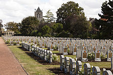
During the First World War, there were two British field hospitals in the nearby Osthoekduinen , the 24th and 39th Casualty Clearing Stations, in June to November 1917 , and in Adinkerke itself in June 1917 a Canadian field hospital, the 1st Canadian Casualty Clearing Station. The 168 Commonwealth soldiers who died there were buried in the war graveyard next to Adinkerke Church.
More deaths, who found their final resting place in the two war graves cemeteries in Adinkerke, occurred during the Second World War during the German attack on France by actually neutral Belgium. During the retreat of the British allied with France to the area around Dunkirk, defensive battles took place here. There were further deaths from shot down aircraft of the British air fleet.
literature
- Serge Van Damme: De Panne, beeld voor beeld. Alongside the beeldhouwwerken en commemorative plaques from De Panne en Adinkerke . De Panne 2005, 64 p.
Web links
- Site about the fossil dunes of Adinkerke, more commonly known as the Cabour dunes
- The website of the amusement park Plopsaland
- Access to the descriptions of four sculptures in public space by Adinkerke on depanne.be
Individual evidence
- ↑ http://www.depanne.be/product/733/adinkerke
- ↑ http://www.depanne.be/product/733/adinkerke accessed on October 12, 2014
- ↑ Adinkerke Churchyard Extension ( Memento from October 20, 2014 in the Internet Archive ) ( English )
Coordinates: 51 ° 4 ′ N , 2 ° 36 ′ E


