
Ghyvelde fossil dunes


The fossil dunes of Ghyvelde (fr: Dune fossil de Ghyvelde ) are a dunes and a protected area which is about three kilometers from the North Sea removed to a length of six kilometers, and with a width of about 600 meters from the French place Ghyvelde by Extends east to the Belgian border. The dune belt continues in a geologically unchanged manner in Belgium for another two kilometers to Adinkerke in the Cabourduinen .
Geological treasure
The area is considered a geological treasure because it is the only area of its kind in France to have remained undamaged. It was built 5000 years ago by the North Sea on the former coastline, as it can still be observed three kilometers north in the Dune du Perroquet , the current coastal dune belt between Bray-Dunes and the Belgian border. (The current Belgian dune area of the De Westhoek corresponds to the old Cabourduinen on the Belgian side .)
After the formation of the dunes, the abundant rain on the North Sea washes away the sea salt in a few decades when new fore dunes finally cut off the sea water . This is already gradually leading to the displacement of the salt-loving pioneer plants and then salt-tolerant species by domestic species, initially grasses and herbs and later, without human intervention, leading to conversion into dune bushes and then into dune forest. This vegetation is still characterized by the fact that the dunes contain plenty of lime in the form of shellfish. This was created and arises from the fact that mussel shells of dead mussels from the sea floor are constantly washed up on the coastline . The in rain in the form of carbonic acid naturally dissolved carbon dioxide then triggers but over the centuries, more and more lime and transports the calcium in the deeper underground. As a result, the soil becomes more and more lime-poor and therefore sterile for many plants. Since almost only quartz sand remains, the vegetation is more like a heather area than a typical area of coastal dunes. After 5000 years the soil is practically free of lime. In the poorest locations there are barely pine trees , which explains the second common name for the area dune aux pins .
Such old dunes are rare anyway and, with their pure, salt and lime-free quartz sand, are easily accessible on the surface and located above the groundwater, ideal for sand extraction in the economically prosperous area.
Protected area, flora and fauna
The 201.79 hectare area has been a nature reserve since 1990 under the name Dune Fossile .
Under the number FR3100475 and the name Dunes flandriennes décalcifiées de Ghyvelde , the area that belongs to the municipalities of Ghyvelde and Moëres has also been under European protection since 2003 as a Natura2000 area by France.
The area is accessible by an 8 km long circular hiking trail.
Maginot Line
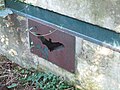
During the construction of the Maginot Line, 24 bunkers of the MOM type and one of the FCR type were built in the fossil dunes of Ghyvelde , which were intended to block Route nationale 1 .
gallery

Bunker in the dune forest

Bunker on the Maginot Line, prepared as quarters for bats


See also
The whole geological and biological system of the North Sea coast and dunes is explained in the visitor and nature education center De Nachtegaal in the nearby Belgian town of De Panne .
Web links
Protected area
to the Cabourduinen
trail
Individual evidence
- ↑ conservatoire-du-littoral.fr
- ↑ inpn.mnhn.fr
- ↑ sentierdunord.free.fr
- ^ Secteur fortifié des Flandres in the French language Wikipedia
Coordinates: 51 ° 4 ′ N , 2 ° 33 ′ E