Aguero Point
| Aguero Point | ||
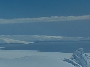
 View from Catalunyan Saddle to Agüero Point (left of center), background: John Paul II peninsula , foreground: Burdick Ridge |
||
| Geographical location | ||
|
|
||
| Coordinates | 62 ° 32 ′ S , 60 ° 41 ′ W | |
| location | Livingston Island , South Shetland Islands | |
| Waters | Stoyanov Cove | |
| Waters 2 | Prisoe Cove | |
| length | 900 m | |
The Agüero Point (English; Spanish Cabo Agüero ; in Argentina Cabo Arroyo ) is a 900 m long headland on the north coast of Livingston Island in the archipelago of the South Shetland Islands . It separates the Stoyanov Cove in the north from the Prisoe Cove in the south , 3.9 km north-northwest of Avitohol Point .
British scientists mapped them in 1968, Chilean ones in 1971, Argentine ones in 1980, Spanish ones in 1991 and Bulgarian ones in 2005 and 2009. Chilean scientists named them after Clodomiro Agüero Soto, a crew member of the Yelcho in the 1916 rescue of the participants of the endurance expedition stranded on Elephant Island (1914– 1917) by the British polar explorer Ernest Shackleton . The namesake of the Argentine name is Jesús Arroyo, who died in 1976 when a Lockheed P-2 Neptune crashed on Mount Friesland on September 15, 1976 together with ten other crew members.
Web links
- Agüero, Cabo in the Composite Gazetteer of Antarctica (English and Spanish)
