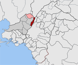
Agii Anargyri
|
Agii Anargyri parish Δημοτική Ενότητα Αγίων Αναργύρων (Άγιοι Ανάργυροι) |
||
|---|---|---|
|
|
||
| Basic data | ||
| State : |
|
|
| Region : |
Attica
|
|
| Regional District : | Athens West | |
| Municipality : | Agii Anargyri-Kamatero | |
| Geographic coordinates : | 38 ° 2 ' N , 23 ° 43' E | |
| Height above d. M .: | 70 m (average) |
|
| Area : | 3,200 km² | |
| Residents : | 34,168 (2011) | |
| Population density : | 10,677.5 inhabitants / km² | |
| Code No .: | 470301 | |
| Structure: |
1 municipality |
|
| Located in the municipality of Agii Anargyri-Kamatero and in the Athens-West regional unit | ||
Agii Anargyri (Attikis) ( Greek Άγιοι Ανάργυροι [ ˈaʝi aˈnarʝiri ] ( m. Pl. ); Alternative transcription Agioi Anargyroi or Aghii Anargyri ) is a Greek city north of the Greek capital Athens . Agii Anargyri is part of the Athens-Piraeus metropolitan area . Until 2010 Agii Anargyri was an independent municipality - since 1963 as a municipality (dimos) - and on January 1, 2011 it was merged with the neighboring town of Kamatero to form the new municipality of Agii Anargyri-Kamatero , where it forms the administrative seat and a municipality.
Agii Anargyri borders in the north on Acharnes, in the northeast on Nea Filadelfia , in the east and southeast on Nea Chalkidona, in the south on Athens with the districts Perissos and Patisia, in the southwest on Peristeri, in the west on Ilion (Ano Liosa) and in the northwest Kamatero. Agii Anargyri lies in the middle of the Attic plain (Lekanopedio Attikis) . There are no visible transitions in the settlement structure or density between Agii Anargyri and the neighboring communities and cities, comparable to the community boundaries in the German Ruhr area .
The city is divided by two major traffic axes that run from north-northeast to south-southwest. The main line of the Greek railway OSE runs from the north-northeast ( Lamia , Larisa , Thessaloniki ) through Agii Anargyri to Athens. A little further east runs in the same direction the motorway 1 (European route 75) from Lamia, Larisa and Thessaloniki coming to Athens. The city's main street, Leoforos Fylis, which runs in a north-south direction, leads directly to Omonia Square in Athens city center.
Agii Anargyri had 26,094 inhabitants in 1971 (population density 8,698 inhabitants / km²). Ten years later, 30,320 people lived in Agii Anargyri (+ 16.20%; population density 10,106.7 inhabitants / km²). In 1991 the population was 30,739 (10,246.33 inhabitants / km²; increase 1.38%).
literature
- Attica, Egina & Salamina. 1: 60,000 . Road Editions, Athens 2004, ISBN 960-8481-88-0 .
Individual evidence
- ↑ Results of the 2011 census at the National Statistical Service of Greece (ΕΛ.ΣΤΑΤ) ( Memento from June 27, 2015 in the Internet Archive ) (Excel document, 2.6 MB)

