
Aherkogel
| Aherkogel | ||
|---|---|---|
 Aherkogel |
||
| height | 2803 m above sea level A. | |
| location | Tyrol , Austria | |
| Mountains | Ötztal Alps | |
| Dominance | 0.4 km → Vorderer Stupfarri | |
| Notch height | 170 m ↓ unnamed saddle with lake | |
| Coordinates | 47 ° 5 '1 " N , 10 ° 47' 52" E | |
|
||
| First ascent | unknown | |
| particularities | steep plate flank | |

The Aherkogel is a 2803 meter high mountain on the front Kaunergrat , a mountain range of the Ötztal Alps . From it two secondary ridges branch off from the main ridge, which pull down towards the Pitztal . The Kitzmörder (2435 m) lies on the northern ridge and the Stallkogel (2605 m) in the northeast ridge . The north ridge of the Aherkogel slopes down towards the Kitzmörder in a striking ridge.
Ascent
According to literature, the normal route up the mountain from the north-western Krummen See (2584 m) leads easily over the ridge to the summit. The base for an ascent is the village of Hairlach , about three kilometers to the northeast , a district of the municipality of St. Leonhard in Pitztal . From there, the path leads first in a westerly and then southwards direction over the Mauchelealpe up to the Brechsee (2145 m) and on to the Krummen See.
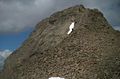
West flank of the Aherkogel
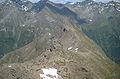
View from the summit
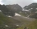
Aherkogel from the Brechsee


Literature and map
- Walter Klier : Alpine Club Guide Ötztal Alps . Bergverlag Rudolf Rother , Munich 2006, ISBN 3-7633-1123-8
- Ludwig Obersteiner: Guide through the Ötztal Alps . Reichenstein-Verlag, Vienna 1925
- Alpine club map 1: 25,000, sheet 30/3, Ötztal Alps, Kaunergrat (the Aherkogel is here at the top of the map)