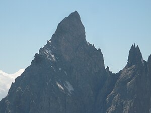
Aiguille Noire de Peuterey
| Aiguille Noire de Peuterey | ||
|---|---|---|
|
Aiguilles Noire de Peuterey from Val Veny |
||
| height | 3773 m slm | |
| location | Italy | |
| Mountains | Mont Blanc massif , Savoy Alps | |
| Coordinates | 45 ° 48 '54 " N , 6 ° 53' 37" E | |
|
|
||
| First ascent | August 5, 1877 by Lord Wentworth with guides Emile Rey and Jean-Baptiste Bich | |
The Aiguille Noire de Peuterey is a 3773 m high mountain in Italy .
The best-known ascent (though not the easiest) is the southern ridge, which was first climbed on August 26th and 27th, 1930 by Karl Brendelet and Hermann Schaller. On the southern ridge, the small ridge towers Picco Gamba, Punta Welzenbach, Punta Brendel, Punta Ottoz and Punta Bich can be distinguished.
Together with the Aiguille Blanche de Peuterey and the Grand Pilier d'Angle, the mountain is part of the Peuterey ridge. In general, it is exceeded in the course of the ascent of the Peuterey ridge to Mont Blanc . It is a difficult and, above all, long tour. The first ascent of the entire ridge was made by Adolf Göttner, Ludwig Schmaderer and Ferdinand Krobath from July 28 to 31, 1934.
Like most of the peaks belonging to the southern Mont Blanc chain, the mountain has a French name, as the Aosta Valley belonged to the Kingdom of Savoy for a long time , where French was spoken.
literature
- Hartmut Eberlein: Alpine Club Guide Mont Blanc Group . 7th edition. Bergverlag Rudolf Rother , Munich 1991, ISBN 3-7633-2412-7 .

