Alabama River
| Alabama River | ||
|
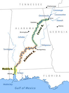
Overview of Mobile, Alabama and Coosa Rivers |
||
| Data | ||
| Water code | US : 154961 | |
| location | Alabama ( USA ) | |
| River system | Mobile River | |
| origin | Confluence of the Coosa River with the Tallapoosa River 32 ° 30 ′ 5 ″ N , 86 ° 15 ′ 43 ″ W |
|
| confluence | with the Tombigbee River to Mobile River Coordinates: 31 ° 8 ′ 11 " N , 87 ° 56 ′ 38" W 31 ° 8 ′ 11 " N , 87 ° 56 ′ 38" W
|
|
| length | 502 km | |
| Right tributaries | Cahaba River | |
| Medium-sized cities | Montgomery | |
| Small towns | Selma | |
|
Miller's Ferry Lock and Dam on the Alabama River |
||
The Alabama River is a river in the US state of Alabama . It is formed by the confluence of the Coosa River with the Tallapoosa River about six miles from Montgomery .
It runs west to Selma , then southwest, until it joins about 72 km from Mobile with the Tombigbee River , which divides there again to the Mobile River and Tensaw River . These run parallel to each other until they come together again in Mobile Bay .
The width of the river varies between 200 and 300 m, its depth is between one and two meters. It meanders very strongly along its entire course, which leads to different length specifications, depending on which measuring method is used. According to a measurement by the US Geological Survey , the river has a length of 502 km. The measurement of the distance traveled by a boat, however, provides a length of 676 km for the entire course of the river.
The Alabama River flows through abundant agricultural land and is connected by railroad lines to the mineral region in central northern Alabama.
Name variants
The river has several designations:
- Alabama Fiume
- Albama River
- Halibama River
- Moville River
- Piache
- Riviere des Alibamons
- Río de Mobila
See also
Individual evidence
- ^ Fite, Emerson D., and Archibald Freeman. A Book of Old Maps . New York: Arno Press, 1926. Reprint, 1969. Delineates American history from the time of the Vikings to the end of the American Revolution. Each map is excellently annotated. p277
- ↑ Swift, Michael. Historical Maps of North America . London: PRC Publishing, 2001. Contains maps from the Public Records Office. p55
- ↑ Swift, Michael. Historical Maps of North America . London: PRC Publishing, 2001. Contains maps from the Public Records Office. p69
- ↑ Swift, Michael. Historical Maps of North America . London: PRC Publishing, 2001. Contains maps from the Public Records Office. p64
- ^ Weddle, Robert S. Spanish Sea: The Gulf of Mexico in North American Discovery, 1500 1685 . College Station, Texas: Texas A&M University Press, 1985. p268
- ↑ Foscue, Virginia. Place Names in Alabama . Tuscaloosa, Alabama: University of Alabama Press, 1989. p7
- ^ Weddle, Robert S. Spanish Sea: The Gulf of Mexico in North American Discovery, 1500 1685 . College Station, Texas: Texas A&M University Press, 1985. p9
Alabama River on the United States Geological Survey's Geographic Names Information System

