Mobile River
| Mobile River | ||
|
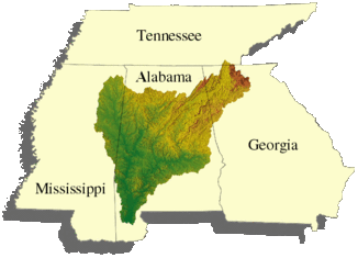
Map of the catchment area |
||
| Data | ||
| Water code | US : 163332 | |
| location | Alabama , USA | |
| River system | Mobile River | |
| source |
Tombigbee River , Alabama River 31 ° 8 ′ 11 " N , 87 ° 56 ′ 38" W. |
|
| Source height | 1 m | |
| muzzle |
Mobile Bay on the Gulf of Mexico Coordinates: 30 ° 39 ′ 22 ″ N , 88 ° 1 ′ 52 ″ W 30 ° 39 ′ 22 ″ N , 88 ° 1 ′ 52 ″ W |
|
| Mouth height | 0 m | |
| Height difference | 1 m | |
| Bottom slope | 0.01 ‰ | |
| length | 72 km | |
| Catchment area | 115,000 km² | |
| Drain |
MNQ MHQ |
282 m³ / s 9018 m³ / s |
|
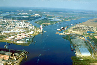
Aerial view of the river at the mouth of Chickasaw Creek, about five miles from where it joins Mobile Bay. The photo is from the construction time of the bridge between Cochrane and Africatown ( US Highway 90 ). |
||
The Mobile River is a river in the south of the US state Alabama . It is created by the confluence of the Tombigbee River with the Alabama River , after 72 kilometers it flows into the Gulf of Mexico in Mobile Bay . Its catchment area covers an area of around 115,000 km² and extends to parts of the neighboring states of Mississippi , Georgia and Tennessee .
It is the fourth largest primary drainage basin that is entirely within the United States . Historically, the river has been the main access route into Alabama. Since the construction of the Tennessee-Tombigbee Waterway , it has been an alternative route to the Ohio River .
Run
Tombigbee River and Alabama River flow together around 80 km north-northeast of Mobile and thus form the Mobile River. The river strives south in a winding course. The river divides about ten kilometers below the confluence, the main arm runs to the west, the Tensaw River forms a bayou of the Mobile River and flows three to eight kilometers further east to the south.
River crossings
Between the junction of the Tombigbee and Alabama Rivers and the estuary, the river is crossed by five traffic routes, two tunnels and three bridges. A new building on Interstate 10 has been discussed for several years . The Alabama Department of Transportation is currently investigating the environmental impact of building bridges and expanding Jubilee Parkway . The location of such a bridge is the subject of discussion.
Web links
- USGS: Mobile River Basin ( April 2, 2008 memento in the Internet Archive ) ( United States Geological Survey website ; English)
- Mobile River System ( February 24, 2007 memento on the Internet Archive ) ( University of Alabama website ; English)
Individual evidence
- ^ Tombigbee River ( English ) In: Geographic Names Information System . United States Geological Survey . Retrieved March 12, 2015.

