Alamada
| Municipality of Alamada | ||
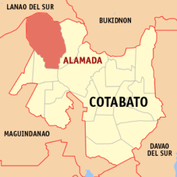
| Location of Alamada in the province of Cotabato | ||
|---|---|---|

|
||
| Basic data | ||
| Region : | SOCKSARGEN | |
| Province : | Cotabato | |
| Barangays : | 17th | |
| District: | 1. District of Cotabato | |
| PSGC : | 124701000 | |
| Income class : | 1st income bracket | |
| Households : | 8412 May 1, 2000 census
|
|
| Population : | 64,596 August 1, 2015 census
|
|
| Population density : | 82 inhabitants per km² | |
| Area : | 787.50 km² | |
| Coordinates : | 7 ° 20 ′ N , 124 ° 34 ′ E | |
| Postal code : | 9413 | |
| Geographical location in the Philippines | ||
|
|
||
Alamada is a Philippine municipality in the province of Cotabato .
geography
Alamada borders the province of Lanao del Sur in the north, the municipalities of Libungan in the south, Banisilan in the east, and Pigcawayan and Buldon in the province of Maguindanao in the west. Alamada is about 20 km from Libungan, from where the town can be reached by road. The provincial capital Kidapawan City is about 100 km and Cotabato City 74 km away. The area is generally hilly and mountainous, and is 500 to 2815 m above sea level. The largest river that flows through the municipality is the Libungan . Alamada lies outside the typhoon zone and belongs to climate type IV of the corona system of the Philippine climate classification with almost evenly distributed rainfall over the year. Exceptions are the driest months of May and September. The average monthly rainfall is between 127 mm and 1154 mm.
Barangays
Alamada is politically divided into 17 barangays .
|
|
history
The history of today's municipality of Alamada goes back to the time of the colonization of the Cotabato Peninsula by the Spaniards. The place was founded in 1595 as a fairly poor rural community. Before the township was established, this area was part of a pilot project to settle landless people ("Land for the Landless") initiated by President Ramon Magsaysay to resettle former members of the Hukbalahap . This project was implemented by the Philippine Army . On January 1, 1954, this area was named Genio Edcor by a general order of the Philippine Army. From January 1, 1954 to August 6, 1961, Genio Edcor was a political sub-unit of the Midsayap township . With the establishment of the municipality of Libungan on August 7, 1961, which until then was part of Midsayap, Genio Edcor became a Baranggay of the newly founded municipality. In the mid-1960s, some residents of Genio Edcor started an initiative with the aim of forming an independent municipality. The borough was established after the Senate passed Republic Act No. 5645 on May 20, 1969 and the House of Representatives on May 22, 1969. The name goes back to the local ruler Datu Amaybulyok Alamada.
Web links
- www.alamada-cotabatoprov.gov.ph ( Memento from October 24, 2007 in the Internet Archive )
