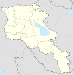
Alaverdi (Armenia)
|
Alaverdi Ալավերդի |
||
|
||
| State : |
|
|
| Province : | Lori | |
| Founded : | city since 1938 | |
| Coordinates : | 41 ° 8 ′ N , 44 ° 39 ′ E | |
| Height : | 1000 m | |
| Residents : | 16,500 (2009) | |
| Time zone : | UTC + 4 | |
| Telephone code : | (+374) 253 | |
| Community type: | city | |
| Mayor : | Sasun Chechumyan | |
| Website : | ||
|
|
||
Alaverdi ( Armenian Ալավերդի ) is a city in Armenia and a formerly important industrial and mining location .
geography
The city is located in the northern Armenian province of Lori , 167 km from the capital Yerevan . It forms the center of the Tumanian region . The village of Sanahin belongs to the urban area . There is a famous monastery complex, a UNESCO World Heritage Site . It is also the birthplace of the brothers Artjom Mikojan and Anastas Mikojan .
The topography of the city is characterized by the rugged mountains and a 300 to 500 m deep gorge. The raging mountain river Debed flows at its bottom .
In 1972 the city still had 21,624 inhabitants. After the shutdown of the copper industry and the independence of Armenia, the number fell to 16,500 inhabitants in 2009.
history
Today's residents like to explain the place name "Alawerdi" with reference to the Arabic-Persian blessing "Allah werdi!" . In a regional dialect, the place name means "red stone" .
As early as 1192, at the instigation of the Armenian Queen Vanani, the Debed Gorge was spanned by the Sanahin Bridge with an arch span of 18 m. It is named after the nearby monastery.
After the conquest of the Caucasus by the Russian Empire , geologists and other scientists came to the region. The mining company Argoutinski-Dolgorukov soon lured hundreds of Greek miners from the Black Sea coast to the valley. They laid the foundations for a mining region based on copper ore - around 1900, Alaverdi was already covering 25% of Russia's copper demand. At the beginning of the 20th century, the mining settlement continued to expand after British and French investments. The railway reached Alaverdi in 1899. In the Soviet era , the expansion of the copper smelter into the Alaverdi copper and chemical combine began. On the mostly unprotected barren and draughty mountain plateaus, new parts of the city were laid out as residential block settlements and cable cars were built for the transport of people and materials. Alaverdi has had city rights since 1938. Due to pressure from the population, the copper and chemical combine was closed in 1989 for health and environmental reasons, but the region's main employer was also lost.
traffic
Alaverdi has a train station on the Tbilisi – Yerevan railway line . It used to be the center of an extensive network of works railways for the copper industry.
See also
literature
- Tessa Hofmann : Armenia - Georgia. Between Ararat and the Caucasus . Mundo-Verlag, Leer 1990, ISBN 3-87322-001-6 , p. 142 .
Web links
- Preliminary Technical File. Alaverdi, Armenia. Kyiv Initiative Regional Program. Pilot Project on the Rehabilitation of Cultural Heritage in Historic Towns, 2012
Individual evidence
- ↑ https://www.panorama.am/en/news/2019/07/01/Alaverdi/2119348 (accessed January 4, 2020)
- ^ Neil Robinson: World Rail Atlas . Vol. 8: The Middle East and Caucasus . 2006. ISBN 954-12-0128-8 , pp. 5f.
- ↑ Article Alaverdi in the Great Soviet Encyclopedia (BSE) , 3rd edition 1969–1978 (Russian)


