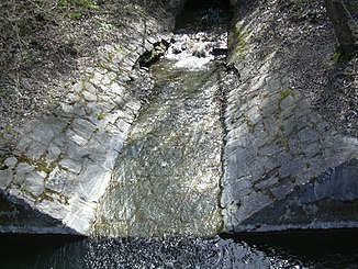
Sistranser Bach
| Sistranser Bach | ||
|
It flows into the Lanser Bach |
||
| Data | ||
| location | Austria , Tyrol | |
| River system | Danube | |
| Drain over | Lanser Bach → Inn → Danube → Black Sea | |
| source | below Sistranser Alm 47 ° 13 '23 " N , 11 ° 28' 5" E |
|
| muzzle |
Lanser Bach coordinates: 47 ° 15 '37 " N , 11 ° 26' 8" E 47 ° 15 '37 " N , 11 ° 26' 8" E |
|
| Mouth height |
570 m
|
|
| length | approx. 6 km | |
| Communities | Aldrans | |
The Sistranser Bach rises near the Sistranser Alm at 1,400 - 1,600 meters above sea level. It is made up of a total of five source streams of almost the same size, which look like a fan on the map. It flows from south to north and flows through the towns of Sistrans , Aldrans and the city of Innsbruck .
At Ambras Castle the stream divides into two arms. The branch flows into the castle park. When the castle falls, the water falls from a height of approx. 20 meters and is one of the most interesting eye-catchers in the water.
The main arm flows along the castle wall and finally flows into the Lanser Bach from the right in the Amras district of Innsbruck . It reaches a length of approx. 6 km.
