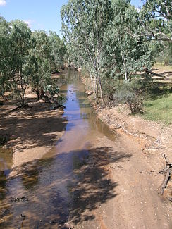
Alice River (Barcoo River)
| Alice River | ||
|
Alice River at Barcaldine |
||
| Data | ||
| location | Queensland , Australia | |
| River system | Cooper Creek | |
| Drain over | Barcoo River → Cooper Creek → Lake Eyre | |
| source | near Strasburg, southwest of Cudmore National Park 23 ° 1 ′ 17 ″ S , 146 ° 4 ′ 37 ″ E |
|
| Source height | 405 m | |
| muzzle |
Barcoo River at Honan Downs Coordinates: 24 ° 1 ′ 40 " S , 144 ° 50 ′ 54" E 24 ° 1 ′ 40 " S , 144 ° 50 ′ 54" E |
|
| Mouth height | 224 m | |
| Height difference | 181 m | |
| Bottom slope | approx. 0.82 ‰ | |
| length | approx. 220 km | |
| Left tributaries | Middle Creek, Middle Creek, Wololla Creek, Mussel Creek, Nugget Creek, Nichol Creek, Boundary Creek, Gum Creek, Patrick Creek, Home Creek, Sandy Creek | |
| Right tributaries | Dry Alice River , Back Creek, Cedar Creek, Hazlewood Creek, St. Andrews Creek | |
| Flowing lakes | Eight Mile Waterhole | |
| Communities | Strasburg, Alice, Killarney | |
The Alice River is a river in the west of the Australian state of Queensland .
geography
River course
The river rises east of the Strasburg settlement , about 15 kilometers southwest of the Cudmore National Park and initially flows about 22 kilometers in a westerly direction. Then it turns its course south to the Tropic of Capricorn . From there it flows to the southwest and shortly thereafter passes under the Capricorn Highway at the Alice settlement . About 20 kilometers southeast of Barcaldine it turns to the northwest and flows towards the city, which it passes in the south and turns its course to the southwest. In Honan Downs , halfway between Barcaldine and Isisford , joins the Alice River in the Barcoo River .
Tributaries with mouth heights
- Dry Alice River - 331 m
- Middle Creek - 330 m
- Middle Creek - 316 m
- Wololla Creek - 314 m
- Mussel Creek - 309 m
- Nugget Creek - 307 m
- Nichol Creek - 302 m
- Back Creek - 293 m
- Boundary Creek - 285 m
- Gum Creek - 279 m
- Cedar Creek - 264 m
- Patrick Creek - 253 m
- Hazlewood Creek - 248 m
- Home Creek - 242 meters
- Sandy Creek - 240 m
- St. Andrews Creek - 236 m
Flowing lakes
- Eight Mile Waterhole - 270 m
See also
Individual evidence
- ↑ a b c d Map of Alice River, QLD . Bonzle.com
- ^ A b Steve Parish: Australian Touring Atlas . Steve Parish Publishing Pty. Ltd. Archerfield QLD (2007). ISBN 978174193232-4 . P. 17
