Schlatenkees
| Schlatenkees | ||
|---|---|---|
|
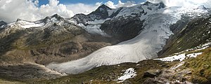
Schlatenkees from the northeast, from the Alte Prager Hütte |
||
| location | East Tyrol , Austria | |
| Mountains | Venediger group | |
| Type | Valley glacier | |
| length | 6.1 km (2010) | |
| surface | 9 km² | |
| Exposure | Northeast | |
| Altitude range | 3670 m - 2100 m | |
| Ice thickness | ⌀ 41 m; Max. 105 m (1987) | |
| Ice volume | 0.378 km³ (1987) | |
| Coordinates | 47 ° 6 '37 " N , 12 ° 22' 48" E | |
|
|
||
| drainage | Schlatenbach → Gschlößbach → Tauernbach → Isel → Drau | |
The Schlatenkees is a glacier in the Venediger Group and is located in the core zone of the Hohe Tauern National Park , east of the Großvenediger . It is located on the territory of the East Tyrolean community of Matrei . With an area of around 9 km², the Schlatenkees is the largest valley glacier in East Tyrol and, after the Obersulzbachkees, the second largest glacier in the Venediger group. The exposure is mainly to the east, in the uppermost area also to the south-east.
The relatively flat nutrient area of the glacier is called the Oberer Keesboden , it is framed by the highest peaks of the Venediger group: Großvenediger and Kleinvenediger ( 3667 m and 3470 m ), Hohes Aderl ( 3504 m ), Rainerhorn ( 3559 m ), Schwarze Wand ( 3511 m ) and Hoher Zaun ( 3467 m ). The glacier flows in a mighty icefall to the Unteren Keesboden , a flat area at an altitude of around 2300 meters. On the Lower Keesboden , a partial stream flows in from the south, coming from the Kristallwand . The little jagged end of the tongue is at an altitude of 2100 meters, above a steep step. The northern part of the tongue is largely free of debris, while the southern end of the tongue, which forms the end of the stream coming from the crystal wall, is completely covered by debris. At the end of the tongue there is a clearly visible glacier gate from which the Schlatenbach exits. This unites on the valley floor of the Gschlösstal with the Vilhabenbach and these form the Gschlössbach , which drains into the Black Sea via the Tauernbach , Isel , Drau and Danube .
At the last peak of the glacier around 1850, the glacier still flowed over the steep step below the current end of the tongue down to the valley floor of the Gschlöss Valley, it crossed the Gschlössbach in its entire width and reached up 20 to 25 meters on the opposite slope. The end of the tongue was at an altitude of 1720 meters and was the deepest end of the glacier in the entire Eastern Alps. Since then, the glacier has continuously receded except for brief interruptions. In this area, which was then still covered by the glacier, in the run-up to today's glacier, a glacier educational trail was established in 1978.
Literature and maps
- Eberhard Stüber, Norbert Winding: Experience the Hohe Tauern National Park. Band Tyrol. Page 69, Tyrolean National Park Fund Hohe Tauern, 2nd edition, Matrei in Osttirol 2003, ISBN 3-7022-1937-4
- Alpine club map sheet 36, 1: 25,000, Venediger group. ISBN 3-928777-49-1
Individual evidence
- ^ WGMS: Fluctuations of Glaciers Database. World Glacier Monitoring Service, Zurich 2012 ( DOI: 10.5904 / wgms-fog-2012-11 ), accessed on February 7, 2013
- ^ World Glacier Monitoring Service (WGMS): Fluctuations of Glaciers 2005–2010 (Vol. X). Zurich 2012 ( online ( memento of the original from March 5, 2014 in the Internet Archive ) Info: The archive link has been inserted automatically and has not yet been checked. Please check the original and archive link according to the instructions and then remove this note .; PDF file; 4, 81 MB)
- ↑ a b Hohe Tauern National Park, East Tyrol: Excursion report Gschlösstal. 2003 ( online ( memento of the original from December 22, 2015 in the Internet Archive ) Info: The archive link was automatically inserted and not yet checked. Please check the original and archive link according to the instructions and then remove this note. )
- ↑ a b University of Vienna, Central Institute for Meteorology and Geodynamics: Seismic ice thickness Austrian glacier. In: Archive for deposit research of the Federal Geological Institute. Vienna 1987, Volume 8, p. 27f ( online ; PDF file; 320 kB)
- ↑ a b Eberhard Stüber, Norbert Winding: Experience the Hohe Tauern National Park. Band Tyrol. Page 69, Tyrolean National Park Fund Hohe Tauern, see literature


