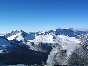
Obersulzbachkees
| Obersulzbachkees | ||
|---|---|---|
|
Obersulzbachkees from the north, from the Keeskogel (2005) |
||
| location | State of Salzburg , Austria | |
| Mountains | Venediger group | |
| Type | Valley glacier | |
| length | 4.7 km (2010) | |
| surface | 11 km² | |
| Exposure | northwest | |
| Altitude range | 3600 m - 1990 m (1975) | |
| Ice thickness | Max. 184 m | |
| Coordinates | 47 ° 6 '36 " N , 12 ° 17' 24" E | |
|
|
||
| drainage | Obersulzbach → Salzach → Inn | |
|
The Ober-Sulzbach-Glacier based on the original photographs by E. Richter in 1880 and 1882. |
||
The Obersulzbachkees is located in the state of Salzburg north of the main ridge of the Hohe Tauern in the Obersulzbachtal .
The Obersulzbach kees drains over the Obersulzbach into the Salzach , a tributary of the Inn . With a length of around 4 kilometers and an area of around 11 km², the glacier is the largest glacier in the Venediger Group and, after the Pasterze, the second largest in the Hohe Tauern . It consists of four large, north-exposed firn hollows, which extend from the north side of the Großvenediger to the part further west below the Maurerkeesköpf . As a result of the retreat of the glacier, these four parts, which formerly united below the Kürsingerhütte , now represent four independent glacier areas.
The Obersulzbachkees became famous through Ignaz von Kürsinger , who in his reports of the first ascent of the Großvenediger in 1841 referred to the then still existing icefall below the Kürsinger Hütte as the "Turkish tent city". Today there is a glacier lake at this point.
The Obersulzbachkees is one of the first glaciers in the Eastern Alps to be mapped. In 1883, Eduard Richter published a map on a scale of 1: 5000 - the first exact glacier map of an Eastern Alpine glacier. Richter tried to compare the glacier levels from 1880 and 1882.
literature
- Mauri Pelto: Disaggregation of Austria's Third Largest Glacier, Obersulzbach Kees. In: American Geophysical Union: AGU Blogosphere: From a Glacier's Perspective , May 11, 2015.
Web links
Individual evidence
- ↑ a b c WGMS: Fluctuations of Glaciers Database. World Glacier Monitoring Service, Zurich 2012 ( DOI: 10.5904 / wgms-fog-2012-11 ), accessed on February 7, 2013.
- ^ A b c World Glacier Monitoring Service (WGMS): Fluctuations of Glaciers 2005–2010 (Vol. X). Zurich 2012 ( online ( memento from March 5, 2014 in the Internet Archive ); PDF file; 4.81 MB).
- ↑ a b c Central Institute for Meteorology and Geodynamics: The current state of glaciers in Austria. Retrieved February 21, 2013.
- ↑ Markus Vollmann: Mapping the snow and ice cover from satellite image data for the validation of snowmelt models in small and medium-sized catchment areas of the Hohe Tauern - Salzburg. Diploma thesis, page 27, University of Natural Resources and Life Sciences, Vienna 2007 ( online ).
- ^ Obersulzbach Glacier Plus Four. NASA Image of the Day , July 1, 2015 (earthobservatory.nasa.gov) - Comparison of two Landsat images August 6, 1988 and September 4, 2013.
- ↑ Kurt Brunner: First large-scale glacier maps with special consideration of the Hohe Tauern. In: Salzburg Geographical Works. 36: 7–21, Salzburg 2000 ( online ( memento of July 11, 2015 in the Internet Archive )).


