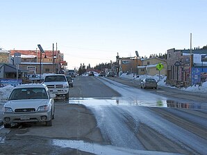
Alma (Colorado)
| Alma | ||
|---|---|---|
 |
||
| Location in Colorado | ||
|
|
||
| Basic data | ||
| Foundation : | December 2, 1873 | |
| State : | United States | |
| State : | Colorado | |
| County : | Park County | |
| Coordinates : | 39 ° 17 ′ N , 106 ° 4 ′ W | |
| Time zone : | Mountain ( UTC − 7 / −6 ) | |
| Residents : | 270 (as of 2010) | |
| Population density : | 300 inhabitants per km 2 | |
| Area : | 0.9 km 2 (approx. 0 mi 2 ) of which 0.9 km 2 (approx. 0 mi 2 ) is land |
|
| Height : | 3224 m | |
| Postcodes : | 80420 | |
| Area code : | +1 719 | |
| FIPS : | 08-01530 | |
| GNIS ID : | 0180003 | |
| Website : | www.townofalma.com | |
Alma is a small town in Park County , Colorado , United States that was founded on December 2, 1873. The 2010 census found a population of 270, up from 169 in the 2000 United States Census . Alma extends over an area of 0.9 km².
At 3,224 m above sea level, Alma is the highest town ("highest incorporated municipality") in the USA.
Web links
Commons : Alma, Colorado - collection of pictures, videos, and audio files
- Town of Alma website
- Alma Foundation website
Individual evidence
- ↑ a b Colorado Municipal Incorporations. State of Colorado , Department of Personnel & Administration, Colorado State Archives, December 1, 2004, archived from the original on September 27, 2007 ; Retrieved June 25, 2017 .
- ↑ ZIP code lookup. United States Postal Service . Retrieved June 25, 2017 .
- ↑ Colorado 2010. (PDF 14.6MB) Summary Population and Housing Characteristics. United States Census Bureau , December 6, 2012, p. 18 , accessed June 25, 2017 .
- ↑ Colorado 2000. (PDF 5.24MB) Summary Population and Housing Characteristics. United States Census Bureau , April 26, 2002, p. 14 , accessed June 25, 2017 .
