Almanzora
| Almanzora | ||
|
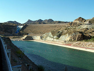
The Almanzora near the mouth |
||
| Data | ||
| location | Almeria Province , Spain | |
| River system | Almanzora | |
| source | North side of the Sierra de los Filabres | |
| Source height | approx. 1900 msnm | |
| muzzle |
Mediterranean Coordinates: 37 ° 14 ′ 19 ″ N , 1 ° 46 ′ 37 ″ W 37 ° 14 ′ 19 ″ N , 1 ° 46 ′ 37 ″ W. |
|
| Mouth height | 0 msnm | |
| Height difference | approx. 1900 m | |
| Bottom slope | approx. 21 ‰ | |
| length | approx. 90 km | |
| Catchment area | 2611 km² | |
| Left tributaries | Rambla de Albox | |
| Right tributaries | Arroyo Albánchez | |
| Medium-sized cities | Tíjola | |
The Río Almanzora is an approximately 105 km long coastal river in the province of Almería in the autonomous region of Andalusia in southeastern Spain . During the Roman times the river was called Surbo .
course
The Río Almanzora rises on the north side of the Sierra de los Filabres mountain range at around 1900 m above sea level. d. It then flows north to Alcóntar , but soon changes its course in southeastern directions, which it maintains until it flows into the Mediterranean at Palomares .
Web links
- Río Almanzora - Info (Spanish)
