
Old woman (Loulé)
| Old | ||||||
|---|---|---|---|---|---|---|
|
||||||
| Basic data | ||||||
| Region : | Algarve | |||||
| Sub-region : | Algarve | |||||
| District : | Faro | |||||
| Concelho : | Loulé | |||||
| Coordinates : | 37 ° 14 ′ N , 8 ° 11 ′ W | |||||
| Residents: | 1997 (as of June 30, 2011) | |||||
| Surface: | 94.33 km² (as of January 1, 2010) | |||||
| Population density : | 21 inhabitants per km² | |||||
| Height: | 200 m | |||||
| Postal code : | 8100-012 | |||||


Alte is a municipality (Freguesia) in the Portuguese Algarve in the Loulé district between the Serra de Monchique and the Serra do Caldeirao of 94.3 km² and 1997 inhabitants (as of June 30, 2011). It has often been described as the most typical and pristine village in the Algarve.
The place is located in a fertile landscape on a slope and has the ruins of a Moorish castle, which was conquered by Dom Paio Peres Correia in 1248 . The three-aisled Matriz Church, which has a Manueline high altar in addition to the Manueline portal of a neighboring church, is worth seeing. Rare Sevillian tiles from the 16th century adorn the Nossa Senhora de Lurdes chapel . Two tree-shaded village fountains, the Fonte Pequena and the Fonte Grande , invite you to take a break at stone tables. Visitors are drawn to the nearby Fonte das Bicas karst spring , which is surrounded by pubs and benches.
Pictures from old

Igreja de Nossa Senhora da Assunção

Old source

Small source
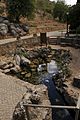
Great source


Individual evidence
- ↑ www.ine.pt - indicator resident population by place of residence and sex; Decennial in the database of the Instituto Nacional de Estatística
- ↑ Overview of code assignments from Freguesias on epp.eurostat.ec.europa.eu
Web links
- Map of the Freguesia Alte (Portugal) at the Instituto Geográfico do Exército
