
Amarapura
|
ဒ ခမရ ပူ ရ Amarapura |
|||
|---|---|---|---|
|
|||
| Coordinates | 21 ° 54 ' N , 96 ° 3' E | ||
| Basic data | |||
| Country | Myanmar | ||
| Mandalay region | |||
| District | Mandalay | ||
| ISO 3166-2 | MM-04 | ||
| height | 30 m | ||
| Residents | 23,200 (2010) | ||

Amarapura ( Burmese : ဒ ခမရ ပူ ရ - Pali : City of Immortals ) is a city 11 kilometers south of Mandalay in Myanmar . It has around 23,200 inhabitants. Administratively, the city belongs to the Mandalay Division . Amarapura can be described as a small fast growing suburb of Mandalay.
history
Amarapura is located south of Mandalay between the Irrawadi River and Lake Taungthaman. The place became the royal capital under King Bodawpaya in 1781 after Sagaing and Innwa were abandoned. In the period from 1823 to 1841, Amarapura lost this status again to Innwa, but again became the capital under King Mindon , until in 1857 Mandalay was finally granted the status of the capital of the empire.
Attractions
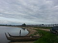
- U-Bein Bridge : At 1,200 meters, it is the longest teak bridge in the world. In the rainy season the level of the water is just below the gangplanks of the bridge.
- Royal Palace: Only ruins remain of the palace itself. Some buildings on the palace grounds, such as the pagodas and the tower, are still standing.
- Patodawgyi Pagoda: This pagoda with a 50 m high stupa dates from 1820.
- Kyauktawgyi Pagoda
- Mahagandayon Monastery
- Bagaya Kyaung: An all-wood monastery founded by King Mindon
- Kwa Yen Temple
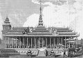
Palace around 1795
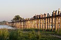
U Bein Bridge in Amarapura

Monks cross the U Bein Bridge at sunset

U Bein Bridge over Taungthaman Lake
U Bein Bridge

Washing cotton in a weaving mill before dyeing it


sons and daughters of the town
- Mindon Min (1808–1878), King of Burma
- Kyaw Ko Ko (* 1992), Myanmar national soccer player