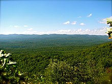
Amicalola Falls State Park
The Amicalola Falls State Park is a State Park in Dawson County in the US state of Georgia . The 335 acre park is 15 miles northwest of Dawsonville and borders the Chattahoochee National Forest . In the park are the Amicalola Falls , the highest waterfalls in the southeastern United States at 222 m.
geography
The area of the park, which is covered with deciduous forest, is located at the southern end of the Blue Ridge Mountains and thus at the southern end of the Appalachian Mountains . The focal point of the park are the waterfalls, the water of which comes from a 1020 m high ridge called Amicalola Mountain . The stream flows down its western slopes until it falls in several stages into the valley of the Etowah River .
Flora and fauna
The area is mainly forested with a deciduous forest of hickory and oak and a mixed oak and pine forest. In spring and summer, numerous plants such as dogwood , laurel roses and rhododendrons bloom , as well as a stock of stemless lady's slippers .
In addition to black bears and deer, turkeys , helmet woodpeckers and eastern triangular snakes also live in the area.
history
Cherokee Indians lived in the area until they were forcibly driven away by the Path of Tears in 1838 . The falls were called Um Ma Calo La in the Cherokee language, which means "tumbling water". They were first mentioned in 1832 by the surveyor William Williamson . Around 1852 a Bartley Crane settled at the foot of the falls who operated a flour mill by the creek near the present visitor center. In 1860 a tent camp was set up by the Methodist Church at the waterfalls, which served as a training and parade ground for both northern and southern troops during the war of secession . Bartley Crane's son, John Crane, ran the mill and shop after his father's death until he sold his land to the state in 1940, which established Georgia's Twelfth State Park on the site. In 1957, the southern end point of the Appalachian Trail was moved to the nearby Springer Mountain , so that the park became the starting point of the long-distance hiking trail. In 1991 the lodge was built.
Tourist facilities
There is a fee to visit the park. Several paths with different degrees of difficulty lead to the waterfalls, and a total of 19 kilometers of hiking trails lead through the park. In the park there is a visitor center, a camping site with 24 parking spaces, 14 overnight huts and on the summit a lodge with a restaurant and 56 guest rooms. An eight-kilometer path leads to the Len Foote Hike Inn , a mountain hotel with 20 rooms that can only be reached on foot. The Hike Inn has its own support association, which also maintains the path on a voluntary basis.
Web links
- State Park website
- Amicalola Falls State Park on the United States Geological Survey's Geographic Names Information System
Individual evidence
- ↑ Sherpaguides.com: Georgia - Mountains. Retrieved August 13, 2011 .
- ↑ Summitpost.org: Amicalola Mountain. Retrieved August 13, 2011 .
- ^ About North Georgia: Amicalola Falls State Park. Retrieved August 13, 2011 .
- ↑ Georgia Trails: Amicalola Falls. Retrieved August 13, 2011 .
- ↑ Hike Inn. Retrieved August 13, 2011 .
Coordinates: 34 ° 33 ′ 38.3 " N , 84 ° 14 ′ 52.7" W.

