Angelokastro (Corfu)
| Angelokastro | ||
|---|---|---|
|
Angelokastro northwest view |
||
| Creation time : | probably from 1071 | |
| Conservation status: | ruin | |
| Geographical location | 39 ° 40 ′ 42.2 " N , 19 ° 41 ′ 13.8" E | |
|
|
||
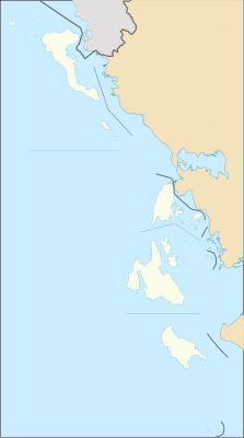
Angelokastro ( Greek Αγγελόκαστρο "Castel Sant'Angelo") was one of the most important defensive structures on the island of Corfu , which is now part of Greece. Its strategic, difficult-to-conquer position on the north-western tip of the island with good influence on the southern Adriatic Sea established a great importance for the fate and development of the island for many centuries.
history
There are reliable indicators that the site where today's Angelokastro is located was fortified as early as the early Byzantine period (5th to 7th centuries). Two processed early Christian stone slabs were excavated there when the restoration of the complex began in 1999. Although there are no specific references in the sources researched so far, it seems likely that the expansion of the complex took place in the 11th and 12th centuries - especially when Byzantium lost its territories in southern Italy in 1071 and Corfu became the border between the Byzantine Empire and his dangerous enemies in the west, the Romanized Normans of Sicily, who from then on regularly attacked Corfu.
When the Crusaders took Constantinople in 1204 and the Byzantine Empire broke up, the island of Corfu changed hands several times until it was conquered by the Angevins of Naples in 1267. In 1272 they finally took advantage of Angelokastro, which is evident from an official report on the change of ownership - the oldest known written reference to Angelokastro. According to the sources researched so far, the castle passed to the Venetians in 1386 and was in good condition at that time. The castle enjoyed significant importance during the Venetian rule (1386–1797) because it offered the local population a refuge from conquerors such as the Turks and the Genoese, and it allowed the control of shipping traffic in the Adriatic, which was a main concern of the republic Venice was. The castellan or governor of Angelokastro was appointed by the council of the city of Corfu ( Kerkyra ), which meant an elevation to the nobility, if this did not exist by default. The techniques of warfare, which changed over the centuries, meant that some of the island's castles were finally abandoned because they no longer met the current requirements. In the 19th century, Angelokastro also suffered this fate, so that the castle was completely abandoned.
Building the fortress
The fort consists of an elaboration of the central northern slope and the eastern steep slope. The west and south sides are protected by very steep terrain. At the highest point is the citadel with its main gate in the north, which was protected by a round tower . The current ruins opposite the main gate were the garrison quarters . The drinking water supply was ensured by three underground cisterns . There was also a small gate system on the south side.
All main walls had battlements , which today only exist on the northwest corner. At the highest point within the citadel stood the small church of Archangel Michael (Taxiarhis Mihael), which was built on the site where a presumably early Christian three-aisled church previously stood. The graves in the west have not yet been explored, so that no statement can yet be made about their origin. To the east is a small chapel dedicated to St. Kyriaki, which was carved out of a huge boulder. The wall paintings preserved here are estimated to date back to the 18th century.
Web links
literature
- Information boards of the "8th Ephorate of Byzantine Antiquities - Corfu Office" at the fort, freely translated from English.


