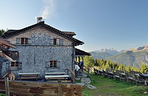
Anna shelter
| Anna shelter ÖTK hut |
||
|---|---|---|
| location | below the Ederplan summit; Tyrol , Austria | |
| Mountain range | Kreuzeckgruppe | |
| Geographical location: | 46 ° 49 '29.4 " N , 12 ° 53' 37.1" E | |
| Altitude | 1992 m above sea level A. | |
|
|
||
| owner | Section Dölsach of the ÖTK | |
| Built | 1882 | |
| Construction type | hut | |
| Usual opening times | Late May to November | |
| accommodation | 25 beds | |
| Web link | Anna shelter | |
| Hut directory | DAV | |
The Anna-Schutzhaus is a refuge of the Dölsach section of the Austrian Tourist Club in the East Tyrolean part of the Kreuzeck group .
location
The hut is located at an altitude of 1992 m above sea level. A. below Dölsach's local mountain Ederplan ( 2062 m ) in the municipality of Dölsach . The Kreuzeck-Höhenweg leads past the hut.
The location offers a comprehensive view of the largest valley floor in Tyrol, the Lienz Basin . Opposite are the Lienz Dolomites , to the south there is a view of the Carnic main ridge with the Hohe Warte , to the west the Villgraten Mountains , the Zettersfeld and further to the northwest the Schobergruppe can be seen.
Hohe Warte in the Carnic Alps
Lienz basin with the Villgraten mountains
history
In 1882 the painter Franz Defregger built a small, ground-level alpine hut on the Ederplan as his summer residence. In 1887 he donated the hut to the ÖTK, who adapted it and named it after Defregger's wife Anna. It was opened in 1888. In 1907/1908 the hut was expanded by a four-meter-deep extension, in 1922 a new kitchen was added and in 1938 a wooden hut created.
The refuge was looked after by the ÖTK section Lienz until 1990, then handed over to the newly established Dölsach section. A general renovation of the building and the construction of additions were then carried out by 1993, taking into account strict ecological aspects and preserving the original character. In 2015 a modern photovoltaic system was put into operation.
The single-storey, shingled wood block building has a veranda in the southeast. The gable roof is covered with wooden shingles and some dormers. The new extension was made of natural stone on the northwest side. In the room there is a brick oven and an open fireplace.
ways
Approaches
- from the Zwischenbergersattel ( 1446 m ), toll, walking time 1½-2 hours
- from Lengberg , Nikolsdorf and Trattenberg, walking time around 4½ hours
- from Winklern via the Zwischenbergersattel, walking time around 3½ hours
- from Lainach via the Zwischenbergersattel, walking time around 4 hours
An official MTB route leads to the hut.
Mountaineering
- Ederplan ( 2062 m ) with homecoming cross, walking time ¼ hour
- Loneskopf ( 2248 m ), walking time 2 hours
- Ziethenkopf ( 2483 m ), walking time 2 hours
Transitions
- Hugo Gerbers Hut ( 2347 m ), walking time 6–7 hours
swell
- Internet presence of the Anna-Schutzhaus. Retrieved November 12, 2018 .
- Wiesauer, Schmid-Pittl: Schutzhaus, Anna-Schutzhaus. In: Tyrolean art register . Retrieved November 12, 2018 .
Web links
- Karl Georg Kreiter: Anna refuge. Retrieved November 12, 2018 .


