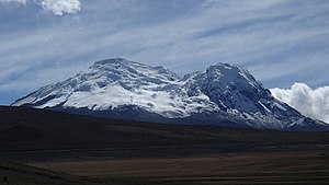
Antisana
| Antisana | ||
|---|---|---|
| height |
5753 m (according to other information 5704 m ) |
|
| location | Ecuador | |
| Mountains | Eastern Andean Cordillera | |
| Coordinates | 0 ° 28 ′ 53 ″ S , 78 ° 8 ′ 27 ″ W | |
|
|
||
| Type | Stratovolcano | |
| Age of the rock | about 800,000 years | |
| Last eruption | 1802 | |
| First ascent | March 9, 1880 , Edward Whymper with guides J. and L. Carrel | |
The Antisana (also Antizana ) is a volcano in the Eastern Cordillera ( Cordillera Real ), the central range of the northern Andes in Ecuador . It is the fourth highest mountain in Ecuador and has a broad, glaciated main summit with four peaks and a large caldera . The middle summit is the highest at over 5700 m , the southern summit is about 5570 m high. On the slopes of the volcano there are several younger block lava flows that emerged from crevices. The only clearly datable eruption took place in the years 1801 to 1802, when a lava flow poured out of a vent on the north-northeast flank of the volcano.
The Antisana is located in the province of Napo near the town of Papallacta on the road from Quito to Baeza , about 55 km east of the capital of Ecuador. Surrounding haciendas require a drive-through permit, which must be obtained in Quito, and this makes access difficult. In addition, the Antisana is a demanding alpine tour that requires a lot of experience and technical knowledge because of its changeable and often cloudy weather for Ecuadorian conditions and its crevice-rich glacier. The Antisana is therefore relatively rarely used by mountaineers.
The Antisana is named for the nature reserve ( reserva ecológica ) Antisana, which was founded in 1993 by the state of Ecuador and covers an area of 120,000 hectares in the provinces of Napo and Pichincha and is one of the “hotspots” of biodiversity in the world.
See also
swell
- ↑ Antisana in the Global Volcanism Program of the Smithsonian Institution (English)
Web links
- Bergnews.com: Antisana
- Antisana in the Global Volcanism Program of the Smithsonian Institution (English)

