Anum (river)
| Anum | ||
|
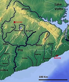
Southern Ghana with the Anum |
||
| Data | ||
| location |
Ashanti Region Ghana |
|
| River system | Pre | |
| Drain over | Pra → Gulf of Guinea | |
| source | Headwaters at Kumawu 6 ° 51 ′ 0 ″ N , 1 ° 16 ′ 0 ″ W |
|
| Source height | approx. 500 m | |
| muzzle | just west of Ofoase Coordinates: 6 ° 11 ′ 46 ″ N , 1 ° 11 ′ 26 ″ W 6 ° 11 ′ 46 ″ N , 1 ° 11 ′ 26 ″ W |
|
| Mouth height | approx. 150 m | |
| Height difference | approx. 350 m
|
|
| Discharge at the Mmuronem A Eo gauge : 1799 km² |
MQ Mq |
9 m³ / s 5 l / (s km²) |
The Anum is a tributary of the Pra in Ghana in the Ashanti region of Ghana.
course
Together with the Pra and its other tributaries such as the Birim and the Offin , the Anum is part of the second largest drainage system in Ghana . The river's water is diverted in many places to irrigate rice fields.
Raw materials and ecology
Gold is mined at Konongo . In the course of the breakdown, the concentration of arsenic in the anum is greatly increased.
Individual evidence
Web links
- US military card TK250 sheet NB30-8 WESTAFRICA, KOFORIDUA, Washington 1959
