Apamea on the Orontes
Apamea on the Orontes (Apamea, Qal'at al-Mudik, Arabic أفاميا or آفاميا, DMG Afāmya , Greek: Απάμεια της Συρίας) is an ancient site in northern Syria , on the Orontes River; it was the capital of the Apamene region, later of the Roman province of Syria secunda .
history
Originally the city was called Pharnakes, after the conquest by Alexander the Great for a short time Pella. The city was re-founded by the first Seleucid king Seleukos I Nikator (312–281 BC) and named after his wife Apame, a daughter of Spitamenes . A Seleucid mint was located here. Shortly before the middle of the 1st century BC Pompey destroyed the fortress, and Apamea was born in 63 BC. Part of the new Roman province of Syria . In the 1st century AD, the city was elevated to a Roman citizen colony under the name Colonia Claudia Apamea .
According to the census of the Syrian governor Publius Sulpicius Quirinius in 6/7 AD, there were 117,000 free men in Apamea, which means that the city (along with its large surrounding area) had a population of around half a million and was one of the largest cities of the Orient (the calculation is controversial, however). In late antiquity , it was the seat of a famous philosophy school and had a large hippodrome . Under Emperor Justinian it was fortified again after it surrendered without a fight to the Persians under Chosrau I , who had chariot races held in the circus. In 613 the city fell to the Persians for several years. Eventually it was pillaged and destroyed during the Muslim conquest of Syria in the 7th century (636–638). Only the fortress remained populated from then on.
archeology
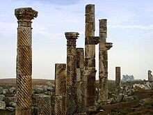
The city lies on a plateau above the Orontestal and covers an area of more than 200 hectares, which is enclosed by a city wall. The well-preserved columned street from the 2nd century AD is one of the most important and best preserved ruins in Syria. With a length of almost 1,600 m and a width of almost 40 m, the street was the largest of its kind. The cityscape also included numerous temples, a nymphaeum, a palace complex, magnificent Roman villas and several church buildings. In the west of the city a theater was built, which with a diameter of 139 m was the largest in Syria. The city founder Seleukos also had a citadel built on a nearby hill, which is now called Qal'at al-Mudiq . This became the seat of the crusaders in the early 12th century, but was recaptured by Nur ad-Din in 1149.
In 1930–38, 1947 and 1953 Belgian excavations took place under the direction of Franz Cumont , and since 1965 new excavations took place under the direction of Jean-Charles Balty . Numerous finds, particularly mosaics, can be found from the early excavations in the Musées royaux d'art et d'histoire in Brussels .
Destruction since 2012
During the Syrian civil war , Säulenstrasse was taken under artillery fire on March 15, 2012.
In the spring of 2013, aerial photos accessible on GoogleEarth showed severe destruction of the archaeological site by large robbery excavation holes that were specifically created to supply the illegal antiques market ( stealing of antiquities ) with new goods. Heavily armed, organized gangs with international contacts are predominantly responsible for this.
Roman auxiliary unit
During the Roman Empire , the Cohors I Apamenorum auxiliary unit was recruited from the city of Apamea and its surroundings.
literature
- Janine Balty (Ed.): Apamée de Syrie. Bilan des recherches archéologiques, 1965-1968. Actes du colloque tenu à Bruxelles les 29 et 30 Avril 1969. Brussels 1969.
- Janine Balty (Ed.): A pamée de Syrie. Bilan des recherches archéologiques 1973-1979; aspects de l'architecture domestique d'Apamée. Actes du colloque tenu à Bruxelles les 29, 30 and 31 May 1980. Brussels 1984.
- Jean-Charles Balty : Guide d'Ápamée. Brussels 1981.
- Immanuel Benzinger : Apamea 1 . In: Paulys Realencyclopadie der classischen Antiquity Science (RE). Volume I, 2, Stuttgart 1894, Col. 2663 f.
- Jean-Paul Rey-Coquais: Apamea (Qalaat al-Mudik) Syria . In: Richard Stillwell et al. a. (Ed.): The Princeton Encyclopedia of Classical Sites. Princeton University Press, Princeton NJ 1976, ISBN 0-691-03542-3 .
- Mohammed El-Zein: History of the city of Apamea on the Orontes from its beginnings to Augustus. Dissertation, Ruprecht-Karls-Universität Heidelberg 1972.
Web links
- Apamea on the UNESCO World Heritage List
- Homepage of the Belgian excavations
- Remains of the city of Apamea in Syria ( Memento from November 30, 2010 in the Internet Archive )
Individual evidence
- ^ New Report on Damage to Syria's Cultural Heritage ( Memento of December 24, 2014 in the Internet Archive ); German: Archaeologik: Fire on Apamea
- ↑ aerial photo with looted excavation holes on Google Maps ; German
- ↑ Rainer Schreg : The complete destruction of Apamea on the Orontes: Syria in April 2013 . Online on Archaeologik from April 30, 2013.
Coordinates: 35 ° 25 ′ 19.3 ″ N , 36 ° 24 ′ 6.1 ″ E


