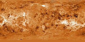
Aphrodite Terra
| Highlands on Venus | ||
|---|---|---|
| Aphrodite Terra | ||

|
||
| Radar image from Aphrodite Terra. Image taken by the Magellan space probe . | ||
|
|
||
| position | 0 ° N , 130 ° E | |
| expansion | 16,000 km | |
Aphrodite Terra ( Latin for land of Aphrodite , the Greek goddess of love and beauty) is the most extensive highlands on the planet Venus .

description
The highlands extend along the equator . Its most prominent districts are Ovda Regio and, to the east of it, Thetis Regio . Often only these two plateaus with their protruding surroundings are called Aphrodite Terra. Occasionally, however, the Atla Regio highland terrain to the east with its large trenches and volcanoes is also included. Depending on that, Aphrodite Terra extends with a length of around 10,000 kilometers or 16,000 kilometers, from around 50 ° East to around 150 ° East or 210 ° East over a good quarter or almost half of the Venus equator, and is about half as big or almost as big as Africa .
In Atla Regio there are the volcanoes Sapas Mons , Ozza Mons and the largest Venus volcano Maat Mons . Of the latter two, a mighty lava flow flows through the Dali Chasma region and forms a lava lake there called Latona . The highland district south of Thetis Regio is characterized by Artemis Corona with the largest ring-shaped rift system Artemis Chasma .
See also
Web links
- Aphrodite Terra in the Gazetteer of Planetary Nomenclature of the IAU (WGPSN) / USGS . Retrieved April 5, 2010
- Aphrodite Terra in the Encyclopædia Britannica (English)
- Aphrodite Terra. Geological map. University of Wisconsin – Green Bay (English)
