Aqsu (Arys)
|
Aqsu Ақсу |
||
|
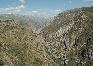
Aqsu Gorge |
||
| Data | ||
| location | Sairam , Töle Bi in Türkistan (Kazakhstan) | |
| River system | Amu Darya | |
| Drain over | Arys → Syr Darja → Aral Sea | |
| source |
Talas-Alatau 42 ° 18 ′ 15 ″ N , 70 ° 51 ′ 57 ″ E |
|
| Source height | approx. 3400 m | |
| muzzle |
Ary's coordinates: 42 ° 35 ′ 51 " N , 69 ° 35 ′ 25" E 42 ° 35 ′ 51 " N , 69 ° 35 ′ 25" E
|
|
| length | 133 km | |
| Catchment area | 766 km² | |
| Drain |
MQ |
9.68 m³ / s |
| Communities | Aqsukent | |
The Aqsu ( Kazakh Ақсу - "White River") is a left tributary of the Arys in southern Kazakhstan .
The Aqsu rises in the far west of the Talas-Alatau on the border with Kyrgyzstan . The upper reaches of the Aqsu in the mountains are in the Aqsu-Schabaghyly nature reserve . The river initially flows in a west-south-westerly direction, later in a westerly direction out of the mountains into the steppe plain . There he turns to the northwest and passes the municipality of Aqsukent . Finally it flows into the Arys, a right tributary of the Syr Darja . The Aqsu has a length of 133 km. It drains an area of 766 km². The mean discharge in Audany Sairam is 9.68 m³ / s.
