Arbogaån
| Arbogaån | ||
|
Course of the Arbogaån |
||
| Data | ||
| location | Örebro län , Västmanlands län ( Sweden ) | |
| River system | Norrström | |
| Drain over | Norrström → Baltic Sea | |
| origin | See Väringen 59 ° 25 '30 " N , 15 ° 26' 5" O |
|
| Source height | 32 m ö.h. | |
| muzzle | at Kungsör in the Mälaren coordinates: 59 ° 25 ′ 50 ″ N , 16 ° 6 ′ 15 ″ E 59 ° 25 ′ 50 ″ N , 16 ° 6 ′ 15 ″ E |
|
| Mouth height | 0.7 m o.h. | |
| Height difference | 31.3 m | |
| Bottom slope | 0.7 ‰ | |
| length | 45 km (163 km with headwaters) | |
| Catchment area | 3808 km² | |
| Drain |
MQ |
38 m³ / s |
| Small towns | Arboga , Kungsör | |
|
Arbogaån at Kungsör |
||
|
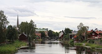
Arbogaån in Arboga |
||
The Arbogaån is a river in Örebro County and Västmanland County in Sweden . It has its origin in Lake Väringen . From there it flows in an easterly direction, passes the town of Arboga and flows into the western end of the Mälaren at Kungsör . The length of the river Arbogaån is 45 km. Including source rivers, it is 163 km. The catchment area covers 3808 km². The river is connected to Lake Hjälmaren to the south via the Hjälmare Canal . From Arboga the river is navigable.
Individual evidence
- ↑ a b SMHI - Sjöareal och sjöhöjd (PDF; 3.5 MB)


