
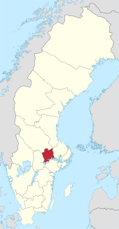
Västmanland County
| Västmanland County | |
|---|---|

|
  |
| Basic data | |
| Historical provinces ( landskap ) : |
Västmanland ( Närke , Södermanland , Uppland ) |
| Residence town (residensstad) : | Västerås |
| Administrative structure: | 10 municipalities |
| District President ( landshövding ) : | Minoo Akhtarzand |
| Letter (länsbokstav) : | U |
| SCB code: | 19th |
| Residents : | 275,845 (December 31, 2019) |
| Area : | 5,658.7 km² |
| Population density : | 48.7 inhabitants / km² |
| Establishment (year): | 1634 |
| Website: | www.u.lst.se |
Coordinates: 59 ° 44 ' N , 16 ° 7' E

Västmanlands län is a province ( län ) in Sweden .
geography
The territory of Västmanland makes up 1.5% of the area of the Swedish national territory.
population
It accounts for 2.7% of the total Swedish population.
Parishes and places
Communities
Västmanlands län consists of the following ten municipalities (Swedish: kommuner ):
| local community | Residents |
|---|---|
| Arboga | 14,087 |
| Fagersta | 13,391 |
| Hallstahammar | 16,346 |
| Köping | 26,214 |
| Kungsör | 8,675 |
| Norberg | 5,690 |
| Sala | 22,894 |
| Skinnskatteberg | 4,393 |
| Surahammar | 10,106 |
| Västerås | 154.049 |
(As of December 31, 2019)
Biggest places
- Västerås (110,877)
- Köping (17,743)
- Sala (12,289)
- Fagersta (11,130)
- Hallstahammar (10,478)
- Arboga (10,330)
(Residents as of December 31, 2010)
Web links
Individual evidence
- ↑ a b Folkmängd i riket, län och kommuner December 31, 2019 at Statistiska centralbyrån
- ↑ Kommunarealer January 1, 2016 at Statistiska centralbyrån (including all inland waters)
Blekinge län | Dalarna County | Gävleborg County | Gotland County | Hallands län | Jämtland County | Jönköpings län | Kalmar län | Kronobergs län | Norrbotten County | Örebro County | Östergötland County | Skåne County | Södermanland County | Stockholm County | Uppsala County | Värmland County | Västerbotten County | Västernorrlands län | Västmanland County | Västra Götalands län