Ardmore, Alabama
|
|
This article was on the basis of substantive defects quality assurance side of the project USA entered. Help bring the quality of this article to an acceptable level and take part in the discussion ! A closer description on the resolving issues is missing. |
| Ardmore | |
|---|---|
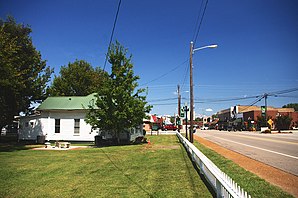
 Ardmore Avenue, City Hall on the left |
|
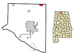
| Location in Alabama | |
| Basic data | |
| State : | United States |
| State : | Alabama |
| County : | Limestone County |
| Coordinates : | 34 ° 59 ′ N , 86 ° 51 ′ W |
| Time zone : | Central ( UTC − 6 / −5 ) |
| Residents : | 1,194 (as of 2010) |
| Population density : | 225.3 inhabitants per km 2 |
| Area : | 5.3 km 2 (approx. 2 mi 2 ) of which 5.3 km 2 (approx. 2 mi 2 ) is land |
| Height : | 269 m |
| Postal code : | 35739 |
| Area code : | +1 256 |
| FIPS : | 01-02260 |
| GNIS ID : | 0113204 |
| Mayor : | Billy Shannon |
Ardmore is a place in Limestone County in the US state of Alabama . According to the 2000 census, Ardmore had 1,034 residents. According to an estimate from 2005, it was 1106.
geography
Ardmore is located in northern Alabama in the southern United States. The northern city limits also form the border with the state of Tennessee .
Nearby places include Ardmore in Tennessee (immediately adjacent to the north), Elkton (7 km northwest), Elkmont (11 km southwest) and Harvest (11 km south). The next larger city with 170,000 inhabitants is Huntsville, about 20 kilometers to the southeast .
history
The city's first name was Austin , in honor of the city's founder, Alex Austin, who built a station on the Louisville and Nashville Railroad here. The city was later given its current name, based on Ardmore in Pennsylvania .
traffic
Alabama State Route 53 runs along the northern city limits , which then merges into Tennessee State Route 7 . Interstate 65 also runs two kilometers west of the city, which runs 1,428 kilometers from southern Alabama to Indiana .
About 2 kilometers west of the city is Ardmore Airport , where around 2260 aircraft movements are made every year.
Demographics
According to the 2000 census, Ardmore had 1,034 residents spread across 460 households. The population density was 195.7 inhabitants per km ². 96.23% of the population were white and 0.87% were African American. Children under the age of 18 lived in 27% of households. The median income for a household was $ 28,352, and 17.9% of the population were below the poverty line .
Web links
- Statistical data Ardmore (Engl.)
Individual evidence
- ↑ Missouri Census Data Center ( page no longer available , search in web archives ) Info: The link was automatically marked as defective. Please check the link according to the instructions and then remove this notice. Retrieved October 12, 2012

