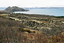
Arnarfell við Þingvallavatn
| Arnarfell við Þingvallavatn | ||
|---|---|---|
|
Arnarfell in the middle distance, in the background across the lake the Hengill volcano |
||
| height | 239 m | |
| location | Iceland | |
| Mountains | Hrafnabjörg | |
| Coordinates | 64 ° 13 ′ 2 ″ N , 21 ° 4 ′ 19 ″ W | |
|
|
||
| Type | Tabular volcano (active) | |
| rock | Palagonite | |
|
Arnarfell seen from the National Park Center in Thingvellir |
||
The mountain Arnarfell on Þingvallavatn (Isl. Arnarfell við Þingvallavatn ) is located in the southwest of Iceland . It protrudes as a peninsula into the lake Þingvallavatn . The elongated mountain extends from northeast to southwest and reaches a height of 239 m.
Surname
The name means in German Adlerberg ( örn = eagle; fell = mountain ) It is likely that eagles once had their nest here, especially since the summit is called Arnarþúfa (German: eagle head ).
Characteristics
The mountain consists of palagonite , was formed under an ice age glacier and belongs to the Hrafnabjörg volcanic system. A smaller peak lies to the north of the higher one and reaches 232 m.
On the west side below the summit there is a pond, the Anbúatjörn ( Eng . Hermit pond ).
Hrafnabjörg volcanic system
The uppermost of the lava fields on the mountain is called Þjófahraun , the thief's lava field , and according to Ari Trausti Guðmundsson is about 9,000 years old - according to Thor Thordarson ea 5,000 - 6,000 years. It comes from the eruption of a volcanic fissure called Eldborgir , which is part of the Hrafnabjörg volcanic system . The lava fields east of the mountain are called Mjóaneshraun , named after the farm located there and the Mjóanes peninsula ( Eng . Narrow peninsula ).
Settlement of the area
At the headland in the southwest of the mountain is a now abandoned farm, which was also called Arnarfell . The farm was managed until 1947, most recently as the property of a doctor from Reykjavík, who brought reindeer from East Iceland there, where he kept them in an enclosure. This reindeer herding had to be given up soon.
Hiking on the mountain
There are marked hiking trails that lead from a parking lot on its northeast side to the Arnarfell. Although the mountain is not high, there is a beautiful view of Lake Þingvallavatn and its surroundings from above.
See also
Web links
- http://notendur.hi.is/oi/geology_of_thingvellir.htm Geology of the Þingvellir area (English)
Individual evidence
- ↑ a b c d e f g Ari Trausti Guðmundsson , Pétur Þorleifsson: Íslensk fjöll. Gönguleiðir á 151 tind. Mál og Menning, Reykjavík 2004, ISBN 9979-32493-7 , p. 20.
- ^ Hans Ulrich Schmid: Dictionary Icelandic - German. With a brief Icelandic theory of forms. Buske, Hamburg 2001, ISBN 3-87548-240-9 , p. 312.
- ^ Hans Ulrich Schmid: Dictionary Icelandic - German. With a brief Icelandic theory of forms. Buske, Hamburg 2001, ISBN 3-87548-240-9 , p. 60.
- ↑ Thor Thordarson, Armann Hoskuldsson: Classic Geology in Europe. Volume 3: Þor Þorðarson, Armann Hoskuldsson: Iceland. Terra, Harpenden 2002, ISBN 1-903544-06-8 , p. 76.
- ↑ Þór Vigfússon: Í Árnesþingi vestanverðu (= Ferðafélag Íslands. Árbók. 2003). sn, Reykjavík 2003, ISBN 9979-9391-5-3 , p. 209.


